“THE STRANGE FORMATIONS of rock, sculpted by time and elements, rise like sentinels over the land, whispering the secrets of ages past,” wrote 19th-century Swiss archaeologist Adolph Bandelier about the striped hoodoos of Kasha-Katuwe, the sacred white cliffs of the Pueblo de Cochiti.
On a Thursday morning, I pull up to the Cochiti Pueblo Visitor Center, pass in hand, eager to return after a nearly four-year closure. For years, one could visit Kasha-Katuwe without reservations—and without crowds. In 2001, the area was declared a national monument, and soon Kasha-Katuwe Tent Rocks attracted nearly 130,000 visitors annually. Over the years, erosion accelerated along the narrow trails, mobs of hikers limited access, vehicles stacked up at the entrance, and the people of Cochiti felt disrespected, their sacred landscape overrun.
“Covid allowed us a pause,” says Jamie Garcia, public affairs specialist with the Bureau of Land Management. The closure gave the land time to heal while the pueblo and the BLM developed a system that would improve the visitor experience, protect the ecosystem, and ensure the pueblo would be treated respectfully. The new two-step permit process, which began in November, includes a day-pass reservation made through recreation.gov and an additional Cochiti Pueblo Tribal Access Pass for $20.
The slot canyons at Tent Rocks.
Photograph by NMTD.
From the visitor center, I follow a Cochiti pilot car, park near the entrance, and head out on the two-mile, out-and-back Slot Canyon Trail. As I enter the shade of the canyon walls, the temperature drops and a breeze flows upslope. The pathway curves through modest boulders, narrowing to shoulder width, before opening to a plaza where ponderosa and juniper cling to crumbling soil, roots exposed like legs and toes.
Evening primrose, Western wallflower, prickly pear, yucca, and Apache plume somehow find a foothold while Woodhouse’s scrub jays scrape for seeds and bugs. A titmouse sits in the neck of a juniper. Ecologically rich, Kasha-Katuwe hosts a wide range of plant and animal species that benefit from the more restricted access.
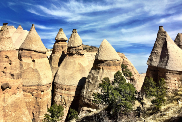
The geologic history of Kasha-Katuwe is laid down in layers of pink and orange, and shades of tan and gray. This landscape formed deep in New Mexico’s volcanic past when pyroclastic flows blasted ash and volcanic glass across the region. As volcanic activity subsided, this tuff was exposed over a million years as wind and water sculpted it into rock-capped hoodoos. Today, the hoodoos appear like sacred beings, spirits on the landscape. It is easy to understand why they are central to the origin stories of the Cochiti people.
Rising 600 feet, the trail wends through the hoodoos to a spectacular overlook. I turn a circle from the Sandía Mountains to the southeast, the Ortiz Mountains to the east, and the Sangre de Cristos to the northeast. Closer, the Caja de Rio and the Dome Wilderness fill my view.
“Please be patient with us,” Garcia says when I speak to her later about the slowed-down process. “We want visitors to experience this special place in a way that honors the land.”
Read more: Three accessible, delightful hikes for even the most casual outdoorsperson.
KASHA-KATUWE TENT ROCKS NATIONAL MONUMENT
Visitors must check in at the Cochiti Visitor Center.
1101 NM 22, Cochiti Pueblo