A deep relationship to the landscape was integral to the Ancestral Pueblo people—and at Bandelier National Monument, that past continues in the present.
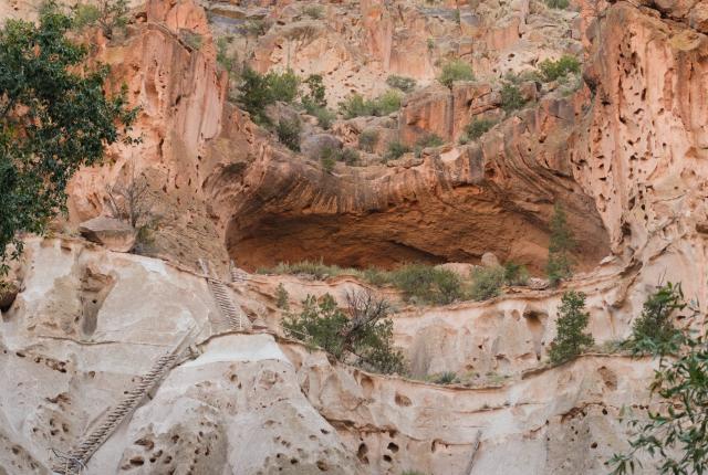
The Alcove House sits 140 feet above the floor of Frijoles Canyon at Bandelier National Monument.
CLIPPERS AND SAWS PROTRUDEfrom volunteers’ backpacks as they hike along a trail through the bottom of a cream-colored canyon in Bandelier National Monument. David Hampton holds an ax in one hand, and Steve Daly carries the biggest of the saws on a rope slung across his shoulders. The blade is so wide, he needs to pivot sideways to squeeze by brush or boulders narrowing the path.
Since 2019, in search of more excuses to hike through his retirement and continue a lifelong exploration of the Pajarito Plateau, Daly has volunteered to maintain trails at Bandelier, joining Hampton, who started volunteering in 2017. As they walk, they scan the Frijoles Canyon Trail for rocks and roots wearing through, places where the path is “furry” with growing vegetation, or, as the day’s work demands, areas covered by trees toppled by wind, water, or age.
“Like a lot of other places,” Daly explains, “the farther out there you get, the fainter the trails get.”
Scott Havemann (right) leads a group of volunteers to help clear Bandelier trails.
Most people who visit Bandelier stay on the Pueblo Loop Trail, the 1.4-mile route winding through Tyuonyi (Qu-weh-nee) Pueblo. The meandering path slots through soft volcanic rock and features climbing ladders into human-carved, cavelike chambers called cavates, where the ceilings are still darkened by smoke from fires that went out centuries ago. Some visitors brave 140 feet of ladders and narrow stairs up to Alcove House, a residence with an airy perch amid the canyon walls.
But some 70 miles of trails wander across Bandelier. We hike up the canyon on the roughly eight-mile route that goes well beyond the people piling up at the bottom of Alcove House, toward a stretch where the rock walls are more blackened pink than cream, and squeeze in around the trail in what some people call “the Narrows.” As we hike, Daly points out structures and rock art he’d passed by for decades before noticing them—a circle of red paint high on the wall, the pale carved ripples of a petroglyph, a four-room structure by a trio of cavates. He also notes a western tanager—a yellow-bodied songbird with a reddish head—flitting by, a garter snake coiling away, the patch of sand that was named Rattlesnake Beach for its longtime resident, aging bear scat, and beaver dams that created ponds and lush pockets of vegetation.
As the trail crew walks up to two trees tangled over the trail, Daly announces, “Here’s our first party.”
Hampton saws quickly through the smaller trunk, then tosses it aside. Scott Havemann, who started volunteering earlier this year, braces the bigger trunk while Daly slices in with a bigger saw. When Daly’s arm tires, he steps back and cheers, “Next in line!”
Havemann takes a turn. “Who needs a gym?” Daly jokes as they sweat. The trunk cracks and splits. Daly swings it sideways off the trail, then warns the others, “Now we get a walk.”
He’d scouted the trail and knew they’d hike another mile before reaching the next tree to clear. We pass charred ponderosa pines, hillsides speckled with charcoal, and heaps of wood piled above our heads from floods that swept over the burnt ground, all remnants of a wildfire. When we reach the last and largest log of the day, Daly notices that the creek, which had been flowing on a previous visit three weeks before our August outing, is now dry.
“That’s a bummer,” he says. “I’ve never in my life seen it dry this high.”
The natural history of fires, floods, and droughts has intertwined with human history at Bandelier National Monument for thousands of years. To the Ancestral Pueblo people who built the structures that are now the park’s centerpiece, these canyons were only ever meant to be a part of a larger journey that saw them moving across and learning from the landscape. Each wildfire, each rainstorm, each dry summer continues to offer lessons in how to thrive and how to adapt. The descendants of those ancestral people in present-day Pueblo communities, including the Pueblos of Cochiti, San Felipe, Santo Domingo (Kewa), Santa Clara, San Ildefonso, and Zuni, see these places not as part of the past, but part of a story that continues to the present and into the future.
“They were dealing with a lot of the exact same things we are, it’s just a different time,” says Cecilia Shields, chief of interpretation and visitor services for Bandelier National Monument and a Picuris Pueblo member. As an example, she points to recent changes in the landscape due to fire or flooding. “How do we as humans adapt to this landscape we loved?” Shields asks. “Because we’re still going to love it, we just have to use it differently.”
Hikers walk through the Tsankawi area of Bandelier.
Ancestral people were very aware of everything happening around them, so much so that they built sometimes entire villages, like Tyuonyi, to mark time.”
Bandelier chief of interpretation and visitor services Cecilia Shields
FOR CENTURIES, THOUSANDS OF people lived on the Pajarito Plateau in scattered villages, with Tyuonyi Pueblo in Frijoles Canyon as a population center. People hunted deer and rabbits, gathered wild plants, raised turkeys, and farmed, growing small plots of corn, beans, and squash. They made pottery, wove cotton into cloth, and used turkey feathers and yucca to make blankets.
The population increased rapidly in the 1200s, with an influx that coincided with the emptying of dwellings at Chaco Culture National Historical Park and Mesa Verde National Park, as some people from those places moved to Bandelier. By the mid-1500s, people from Bandelier were moving elsewhere. Oral traditions say the land was teaching them how to live on it, and the land also let them know when it was time to move on, Shields says, which might be what’s reflected in the scientific record as a period of drought.
That people built, added on to, and modified so many structures at Bandelier for so many years suggests stability, successful social agreements, and sophistication, says Jon Ghahate (Laguna/Zuni), an educator and Pueblo culture historian. The villages they built “are evidence of human innovation, creativity, self-governance,” he says, noting that the changes to their homes are just like our modern challenges living in a place. “They realize, Oh, I need another room for my in-laws to come. Now my children have children, so I need a bigger space. Or, I need more space to hold my crops.”
A reconstructed kiva rewards visitors willing to climb to Alcove House.
As Ancestral Puebloans migrated, they took some practices with them and modified others to their new homes. People continued to make black-and-white pottery, as is also found at Mesa Verde, but the clays and designs were different at Bandelier. Like Ancestral Pueblo people had at Chaco in northwest New Mexico, those living at Bandelier kept close watch on the sky: On the winter solstice, the sun rises in line along an entrance to Tyuonyi Pueblo.
“Ancestral people were very aware of everything happening around them, so much so that they built sometimes entire villages, like Tyuonyi, to mark time,” says Shields, who has risen early and bundled up to guide the public for that chilly sunrise event. “Just watching the sun come up and light up the canyon is pretty phenomenal.”
Ancestral Pueblo people never planned for their use of Frijoles Canyon to be permanent, Shields says. What they built was intended to fade back into the earth. Respect for that principle has left many of the sites at Bandelier unexcavated or, as Shields says, “still in their original path to return.”
So today, Tyuonyi doesn’t impose itself. Knee-high stone walls hint at the shapes of living spaces and leave much to be imagined. Some 3,000 archaeological sites scatter across the Pajarito Plateau, but only a visitor who knows how to recognize a heap of rocks as a former wall, the pit of an eagle trap, or the row of stones from a dam for irrigating fields is likely to recognize them. Those people, however, can’t walk more than a few minutes without seeing something.
The Bandelier visitor center exhibits tell a rich story.
The living descendants of the people who lived at Bandelier still reside in pueblos along the Río Grande, and continue to rely on traditional knowledge developed there for medicine, natural teas, or just where to find piñon nuts for topping homegrown blue corn pancakes. More than 23 tribal communities connect to Bandelier. The Park Service illustrates those links through displays of pottery made by modern Pueblo potters that closely resemble the ancient ceramics found at Bandelier; plus a garden that still yields a harvest of corn, beans, and squash, as Pueblo farmers have grown for centuries; and regular Pueblo artisan demonstrations and dances.
Bandelier’s human history is its centerpiece, but the roughly 24,000 acres of wilderness within the park also offer an array of habitats for native wildlife, including bears, bobcats, mountain lions, and coyotes. The Park Service has worked to restore native species that Ancestral Puebloans would have known.
The federal agency released Río Grande cutthroat trout into the Rito de los Frijoles and Rio Capulin in 2019, and Río Grande chub and sucker in 2022, part of an effort for both the ecosystems and for barbless catch-and-release fishing. The chub and sucker were doing well until a flood in September 2024 wiped them out. They were restocked in 2026, higher up in a canyon less likely to see flooding.
Relax on the Pig & Fig Cafe patio in White Rock.
But this year has been tough for wildlife since water levels are low and not much is growing to feed them. Beavers relocated to Frijoles Canyon created ponds and pockets of emerald green, doing more to improve water quality in streams and riparian habitats than human restoration teams could. This summer, with New Mexico’s ongoing drought, those ponds were dry and the inner workings exposed: the passageways into lodges open to the air and no beaver to be found living inside the heaps of dry sticks. How the ponds continue to support other wildlife still comes through, however.
As I hiked along the creek one August morning, a group of kids leaned over the edge of a bridge, looking into the streambed and remarking on the animal prints they spotted in the damp creek bed near a dam holding just a puddle—birds, raccoons, deer have all passed by and dimpled the mud. “That’s from a bear,” an adult with them says. “See the claws?”
Refuel with a sopaipilla burger at Sirphey at Bandelier.
HISTORICALLY, BANDELIER’S PONDEROSA pine forests saw low-intensity wildfires every five to 10 years. But overgrazing and routine wildland fire suppression created conditions for massive and severe fires. Chris Judson had only spent a year working for Bandelier when La Mesa Fire took off in June 1977. Its 15,000-acre footprint sounds small compared to the massive fires the Southwest has seen since, but at the time, it was the largest and most intense fire to burn in the Jemez Mountains since the 1800s.
Judson still recalls fire ecologists talking afterward about how differently that wildfire behaved. One fire management officer would write that La Mesa was a “wake-up call”—a large-scale, high-intensity crown fire that quickly threatened an urban area. La Mesa foretold what would come with the Cerro Grande and Las Conchas wildfires, which burned tens to hundreds of thousands of acres of the Jemez Mountains in the early 2000s.
“The whole world was so interested and curious because the great big fires, like what we see now in Washington and Hawaii and Los Angeles, they weren’t happening yet,” says Judson, who often worked as a wildfire information officer, answering phone calls from the public and newspapers worldwide. “Now, they are, but this was kind of like a harbinger.”
Different places in Bandelier show the contrast: Where even those massive fires burned at low intensities, mature ponderosa pines have a bit of burnt-marshmallow char at the edges of their bark but still hold on to their green overstory. Where fires burned hotter and at greater extremes, like what a hiker passes through on the Alamo Boundary Trail in the park’s higher elevations, those mature pines are all but gone, replaced by young thickets of aspens and locusts. A thorough search might find a few knee-high ponderosa seedlings, working their way up through ground that burned so hot the soil fused into a hardened, glassy layer that’s almost waterproof. There, the ponderosa pine forest may never return.
Retired Park Service staffer Chris Judson.
During Las Conchas Fire, as flames encroached on the visitor center, Judson and other staff removed all the objects on display. They wrapped the pottery in old uniforms. They left with the last piece, a beautiful olla, packed in a flag.
“Just trying to round up everything we could to make it work and save all those beautiful things that have such cultural importance,” she says. “It was a huge hurry—but it was all done so carefully.”
The visitor center didn’t burn, and after waiting safely in a conference room at regional headquarters for months of post-fire flooding, those objects were returned to their places. But some changes haven’t been so easy to reverse.
The Falls Trail used to connect the visitor center to the Río Grande, but floods in 2011 and 2013 washed out the trail leaving steep cliffs cutting through it. The trail currently ends at a waterfall overlook 1.5 miles from the parking lot, about half a mile short of the river.
Living spaces in the Alcove House.
Three miles of the Upper Frijoles Trail were lost to flooding in 2013, closing a section of the once-popular point-to-point hike. Paid crews have rebuilt two miles, but it’s a struggle for the volunteers to keep those two miles clear while waiting for the third to be finished. Backcountry trails once frequented by backpackers now make for forbidding terrain, as canyons previously shaded with ponderosa pine forests and lined with perennial streams are sunbaked and dry.
“It’s tough country to hike now,” Daly says. “Not a lot of water, not a lot of shade.” He’s cut it close, returning once from a solo overnight backpacking trip with only an inch of water left in his bottle.
Shields connects these changes to similar challenges during ancient times. “This landscape is different, how are we going to adapt to it?” she says. “Is it going to be that we move, or we just do shorter hikes now?”
Follow the pathways of Ancestral Puebloans at Tsankawi.
PART OF WHAT CONTINUES TO DRAW people to Bandelier as visitors are the opportunities to engage so directly with these Ancestral Pueblo sites: to crawl into a cavate, take a seat, and glimpse a view of the world someone would have had 600 years ago.
The national monument includes a separate unit, accessed off NM 4, called Tsankawi, that’s become particularly appealing for visitors looking for that experience. There, ancient pathways have been worn deep enough into the soft volcanic rock to feel a palpable connection to walking where people have walked for centuries, stepping in those footfalls.
Often, few other people are visible on the trails. The view from the unexcavated pueblo on the mesa looks right to the Pueblo of San Ildefonso, for which Tsankawi is an ancestral home, a visual connection to that story of movement.
It’s a remarkable site, Shields says, and perhaps the site in Bandelier that is most in need of a more widely understood message around how to visit with respect. Some cavates are closed to the public, and staying on trails matters for both natural and cultural reasons. Consider visiting with the same manners taken to anyone else’s home, Shields says: Don’t rearrange the furniture, scratch the walls, or trample through yard instead of using the sidewalk.
The remains of stone walls hint at the living spaces of Tyuonyi Pueblo.
Tsankawi’s growing popularity prompted recent upgrades to expand and pave the parking lot and trailhead. Construction anticipated late this year is expected to add a circular stone viewing platform by the pueblo on the mesa. The National Park Service is working with San Ildefonso Pueblo to balance preservation of that site with allowing visitors to experience it.
Throughout Bandelier, when Shields leads tours, she prompts visitors to think about the physical landscape and how people learned from it—which plants to use, which materials to build with in a volcanic landscape, how to be resilient through changes like weather and wildfires. But she also encourages them to take a wider view, both across the landscape and in a more introspective level, thinking about generations journeying across and being taught by the same landscape.
“Think outside of what you would normally look at—look high, look low, even just look inward, and find those connections,” she says. “No matter how many times you visit, you always have a different experience.”
Elizabeth Millerfirst visited Bandelier National Monument on a December afternoon and still prefers those winter days for finding quiet moments to contemplate life in Frijoles Canyon.
PARK PLACES
Elevate your Bandelier trip with these spots.
Eat.
Sirphey at Bandelier, the on-site cafe, showcases burgers and frybread, but owner and chef Prashant Jain mixes in curry specials and drinks like mango lassi from his native northern India. Tables sit among marketlike shelves of snacks and an ice cream cooler, or on a sun-warmed patio. Swing by Pig & Fig Cafe, in nearby White Rock, to stock up on burritos, sandwiches, salads, and comfort food icons like pork schnitzel and fettuccine on the way to or from the park.
Stay.
The National Park Service runs the Juniper Family Campground. Sites come with picnic tables, fire rings with grills, and food and bear lockers. Two additional group campsites for up to 50 people are available at the Ponderosa Group Campground. These mesa-top sites are linked to the main canyon by trails (the steep Frey Trail descends 450 feet from Juniper Campground to join the Pueblo Loop Trail near the cliff dwellings, while the longer Ponderosa and Frijoles trails link the Ponderosa Campground). For those looking for four-walled accommodations, try the Hampton Inn & Suites just across from the visitor center in nearby White Rock. At Pueblo Canyon Inn and Gardens in Los Alamos, book a room in the main house, a guesthouse with a kitchen, or a studio cabin.
Shop.
The Western National Parks Association Store, the shop by the visitor center in Bandelier, stocks books, puzzles, posters, T-shirts, mugs, and postcards for souvenirs, as well as Native-made pottery and jewelry.
Do.
Ranger-led hikes to Tyuonyi depart around 7 a.m. for a few days before and after the winter solstice (December 21) to see the sunrise alignment.