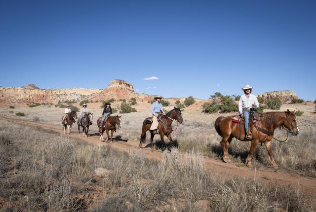
FOR A HORSE RIDE
Trails into the Pecos Wilderness often start with difficulty, climbing out of the Pecos River canyon and up into the high peaks. “The trade-off is that the scenery and the terrain are stunning,” says Colleen Davy, owner of Cloud 9 Trails, who has been guiding horseback trips in the Santa Fe National Forest for 11 years. The wilderness rides she leads ascend Jacks Creek Trail on steep, rocky terrain. But then, they top out at Round Mountain, a high lookout.
“That’s like the money shot,” Davy says. “That’s where everybody wants to take their pictures, because you can see down the whole Pecos Canyon.”
Riders continue from there through some aspen trees and across wide, grassy meadows, then break for lunch in another stand of aspens. The wilderness ride requires some physical fitness. So, for a similar but more beginner-friendly outing, she connects old roads on a more gentle ride to Rowe Mesa.
ALSO TRY: In Abiquiú, tour the rosy cliffs of Ghost Ranch by horseback on guided rides that skirt the mesas and look toward Cerro Pedernal. Horse packing might be the most efficient way to explore the expansive Gila National Forest. Try the 18-mile loop up Granny Mountain, Ring Canyon, and Little Creek Cutoff trails from the recently renovated horse-friendly trailhead at Woody’s Corral, near the Gila Cliff Dwellings National Monument.
Hike the Río Grande Trail in the Río Grande del Norte National Monument.
FOR THE LONG HAUL
The black edge of an ancient volcanic flow rings the canyon. Vultures cruise by at eye level as they ride updrafts surging over the rim. The branches of piñon and juniper trees swing in the wind.
The river itself runs silent, far below, a streak of white between dark, well-polished boulders. Trails to reach it descend more than 1,000 feet through yucca, sage, and ponderosa pines and along springs that well up and create emerald oases. Cinder cones poke up toward a blue sky daubed with clouds that feel close overhead.
The northern terminus of the Río Grande Trail, a planned 500-mile trek that will follow its namesake river, uses trails in Río Grande del Norte National Monument that feel wild and remote. The six-mile Rinconada Loop Trail is one section of about 90 miles already officially designated in the larger route that spans mesquite flats, placid reservoirs, and cottonwood groves through New Mexico from the Texas to Colorado state lines. In addition to exploring a range of ecosystems, the trail will reveal New Mexico’s layered cultures and histories. Because while much of the Río Grande Trail is still in the planning and design stages, in more fundamental ways, people have always followed the river.
In 2015, state legislators voted to create the cross-state route. With a completed master plan, the project has been gathering speed as planning firm Pland Collaborative studies where and how to move a bold idea onto real ground. The patchwork of existing trails and state park land that has already been designated as part of the Río Grande Trail makes up less than 20 percent of the planned route.
“We’re just chipping away at it a mile at a time,” says Dan Majewski, a senior planner with Pland Collaborative. “Every mile is a different story.”
The Río Grande Trail follows a route that people have traversed for centuries.
The vision, ultimately, is to create a continuous route for hikers, bikers, and horseback riders, but it faces many challenges. For one, unlike other long scenic trails, the Río Grande Trail navigates urban areas, including Albuquerque, Las Cruces, and Santa Fe.
“That’s just kind of the nature of the Río Grande—it’s where everyone lives,” Majewski says. “We see it as an opportunity for storytelling, for cultural interpretation. The Río Grande is the throughline for so many of us in New Mexico. It’s a way of telling the story of the river, of El Camino Real, of this corridor that’s been used for millennia. It’s a way to connect all these communities.”
Signage is planned to help explain some of those links, the gateway communities, and tribal and colonial history. There’s a chance to tell a narrative about the river itself, too, and explain why so many stretches are just dry sand and what some solutions might be to see more water in the river. Dams and diversions have disconnected the river, Majewski says, but the trail could be a way to engage with it and repair those gaps.
Most users of long scenic trails actually aren’t overnight hikers, they’re day hikers. In that sense, the Río Grande Trail already offers some accessible walking and biking, including the trails at Río Grande del Norte, the Bosque Trail through Albuquerque, and trails through Elephant Butte State Park. Sunland Park has secured roughly $500,000 in grant funding to build trails at the southern terminus.
Farther north, though, the currently proposed routes—there are two under consideration—venture away from the river. That approach, generally, is in deference to the pueblos, who have asked that trail planners not come through tribal lands. The path might instead shadow the Santa Fe River, a Río Grande tributary, into the Sangre de Cristo Mountains foothills, or it could follow US 84, using the pilgrimage route to Chimayó, which follows the Old Spanish Trail and would improve that corridor for everyone on Good Friday.
The hope, ultimately, is to see it become a route that reconnects ecosystems and people across time and space, a pathway to telling stories old and new.
ALSO TRY: The Continental Divide Trail crosses 3,100 miles through New Mexico, Colorado, Wyoming, Idaho, and Montana. Day hikes and overnight backpacking trips abound in New Mexico, traversing ponderosa pine forests, red canyons, grassy meadows, and subalpine forests. The Monumental Loop weaves a 254-mile figure-eight on singletrack, backcountry dirt roads and sandy washes through the Chihuahuan Desert in the Organ Mountains–Desert Peaks National Monument. Bike packers in the robust biking community of Las Cruces designed the route.
Río Grande Trail
90 designated miles in or near the Río Grande del Norte National Monument, Albuquerque, Socorro, Elephant Butte, Truth or Consequences, and Las Cruces; riograndetrailnm.org
Connect with Jemez Pueblo on Red Rocks Trails.
FOR THE SLOT CANYON SEEKER
Brick-red earth lies underfoot along the 1.2-mile Red Rocks Trails, which depart from Jemez Pueblo’s Walatowa Visitor Center before heading across piñon and juniper woodland toward red sandstone cliffs and towers looming over treetops.
Voices carry across the quiet desert, including that of a raven, its shadow flickering across the textured rock as it flies. A spur off the trail delves into the deep shade of a slot canyon. A little sun filters in, catching on pockets sculpted into the wall and illuminating trees that boldly sprouted from ledges far off the ground.
Jemez Pueblo issues permits to explore the trails and runs guided hikes from the Walatowa Museum, which shares some of the tribe’s history in the area, Towa cultural objects and crafts, and a replica field house like those that dotted the canyons centuries ago. On the tours, a Jemez guide explains the tribe’s emergence story—where they came from in the Four Corners area, how they migrated to be where they are today, and how they’ve fought through challenges to stay here.
“We strongly believe that being out in nature allows our guests to connect with our history in an impactful way,” says Chaz Rose, marketing manager and head of the tourism department at Jemez Enterprises. Sharing that history with guests on tribal lands, he says, gives them a deeper appreciation for the land. When he talks about the history, Rose delves all the way back to the geologic forces that shaped and reddened those canyon walls.
While the trail typically closes at 4 p.m., Red Rocks Sunset Socials reopen the path for evening hikes this summer with a food truck and music on alternating summer Fridays. “It’s the first time the trails have been open in the evening for the public,” Rose says. “You’ll really see the trail come to life during sunset and see those colors change.”
ALSO TRY: Pale tuff, ash, and pumice deposited by volcanic explosions wore away into pillars and cracks at Kasha-Katuwe Tent Rocks National Monument, in Cochiti Pueblo, where the three-mile round-trip Canyon Trail threads thin canyons before climbing a steep 630 feet to the mesa top. The 4.4-mile one-way Little Bear Trail traverses a shelf of land that divides two forks of the Gila River, before dropping more than 1,000 feet into the narrow Little Bear Canyon, in the Gila National Forest, and ending at the impressive cliff walls at the Middle Fork of the Gila River.
Red Rocks Trails
Walatowa Visitor Center, 7413 NM 4, Jemez Pueblo; 505-494-1965, nmmag.us/redrock
Follow mining history at Cerrillos Hills State Park.
Photograph by Mary Robnett.
FOR THE HISTORY BUFF
Five miles of trails roll over the hillsides at Cerrillos Hills State Park, where Indigenous people once dug turquoise and galena, a mineral used in pottery glaze, and later, Spanish colonists extracted silver and lead for munitions. Pathways like the 0.3-mile Cortez Mine Trail meander past those historic mines, with interpretive signs that share some of that 1,100-year history. Link up with other trails to create a jewel of a day. Nearby, Broken Saddle Riding Company offers horseback adventures for a fuller picture of what mining life was like.
ALSO TRY: The moderate 2.3-mile Civil War Trail near Pecos National Historical Park climbs 500 feet on dirt and gravel to the site of one of the more significant Civil War battles in the West, the 1862 Battle of Glorieta Pass.
Find artistic touches along the Albuquerque Rail Trail.
Photograph courtesy of the City of Albuquerque/Adolphe Pierre-Louis.
FOR THE CITY DWELLER
In downtown Albuquerque, a quarter-mile segment of paved path pops with shade structures, benches, and newly planted native landscaping. At night, LED surface and overhead lights illuminate the way along the Albuquerque Rail Trail.
When the city planned this section of the multiuse pathway, it wanted to make the case to residents for a full seven-mile loop that repurposes old rail lines into walking or biking routes that link downtown neighborhoods. Two signature iron archways, each carved with decorative features, frame the ends of the segment. When the sunlight comes through, one casts the image of a saw on the ground, for the Sawmill neighborhood the trail hopes to help revive, and the other, a flamenco dancer. For the design, the city looked to one of its own: world-renowned Albuquerque architect Antoine Predock, whose New Mexico works include the Río Grande Nature Center, in Albuquerque, and the Spencer Theater for the Performing Arts, in Alto.
The Sawmill segment, which runs from Bellamah Avenue to Tiguex Park, was completed last October. Progress continued despite the Trump administration’s withdrawal of $11 million in federal funding awarded through the U.S. Department of Transportation, a move the city is challenging in court. Although some sections are still in the design and planning stages, city officials hope the entire route can be completed in the next eight years. It is expected to run through neighborhoods including the historic West Old Town, link to amenities such as the National Hispanic Cultural Center and the BioPark, and add access to existing transportation infrastructure, such as the New Mexico Rail Runner Express.
End with a reward at Sawmill Market.
Photograph courtesy of the Sawmill District.
“It takes you through all of these different historic neighborhoods, and you get a little flavor of each of them,” says Terry Brunner, director of Albuquerque’s Metropolitan Redevelopment Agency. “We’re linking together a lot of different elements that are all pieces of Albuquerque’s history.”
The trail marks the latest step in overhauling the historic Sawmill District, which once housed logging sawmills and manufacturing businesses, and progress in a long-discussed idea to convert former rail lines into multiuse paths. Businesses and housing developers have expressed interest in investing along the trail, Brunner says. But he’s already seen the first marks of success while out riding his bike: There’s always someone out walking a dog or playing with their kids. “These trails draw people,” he says.
ALSO TRY: The Pecos Riverwalk, in downtown Carlsbad, frames its namesake river for nearly five miles of paved trails, passing the Carlsbad Water Park, playgrounds, a public boat launch, and a beach. The Las Cruces Urban Trail System has built up 21 miles of walking, biking, and running paths that ring the city. Savvy locals also know how to piece together the “ditches,” riding dirt right-of-ways alongside irrigation canals around town.
Albuquerque Rail Trail
Bellamah Avenue to Tiguex Park, Albuquerque; abqrailtrail.org
Bring your bike along on the New Mexico Rail Runner Express.
Photograph courtesy of Rio Metro Regional Transit District.
FOR A RAIL OF A DAY
The Rail Runner Loop links together paved and unpaved trails and streets with bike lanes to explore cultural and culinary delights in Bernalillo, Corrales, and Rio Rancho. Start by taking the New Mexico Rail Runner Express, which has bike racks on every train, to the Sandia Pueblo station, pedal west into Corrales, then north through the cottonwoods along the Rio Rancho Bosque trail, with enriching detours at the Bernalillo Community Museum or Coronado Historic Site, then dip into the breweries for a refreshing reward and a bite to eat before hopping back on the train at the US 550 station.
ALSO TRY: The Santa Fe Rail Trail begins in the Santa Fe Railyard, near the boarding zones for Sky Railway that now takes themed tours on the old spur line to Lamy. North of Rabbit Road, the trail is paved and crosses city streets, while the southern half is packed dirt and crushed gravel as it rolls out for a total of about 17 miles one way. Near Cloudcroft, the Mexican Canyon Trestle Trail takes hikers to an overlook for the trail’s namesake trestle on an out-and-back trek of 2.25 miles each way. It starts near the old train depot and passes other traces of the historic railroad, complete with big vistas, benches, and water stations for dogs.
Rail Runner Loop
Connect to the loop at one of three stations: Sandia Pueblo, Downtown Bernalillo, and Sandoval County/US 550; 866-795-7245, nmmag.us/rail-trail
Cairns mark the Zuni-Acoma Trail.
Photograph courtesy of the NPS.
FOR OTHERWORLDLY LANDSCAPES
A small cloud blunts the edges of the sun and makes the sage glow blue as the scent of it wafts over the trail. When the clouds pile up and rain falls, depressions dotting the volcanic rock on either side of the path fill with water, making ephemeral pools that reflect the sky all over El Malpais National Monument. Archaeologists have found signs that the Ancestral Puebloans in those areas knew exactly where to go for water caught in those rocky lava formations.
Spanish settlers called them “badlands” for the treacherous terrain. Early wagon travelers lamented the long detour required to avoid the black rock that creased, heaped, folded, and occasionally gaped open in lava tubes. But Indigenous people may have seen this land as a place of resources of last reserve: In 2020, Scientific Reports published research showing that Ancestral Puebloans sought out ice lingering deep in some of the lava tubes during a drought between roughly 150 and 950, and lit fires to melt some of those reserves for water.
Follow the footsteps of those earlier, savvier travelers on the Acoma-Zuni or Zuni-Acoma Trail, depending on which side you start on, which traverses about eight miles of the lava fields at El Malpais. Set a car shuttle to hike it end to end. Footing can be rough and uneven, but starting from NM 53 on the Zuni-Acoma Trail, the route stays on less rugged terrain for up to five miles, making it a more family-friendly option.
ALSO TRY: At Ah-Shi-Sle-Pah Wilderness south of Farmington, hikers roam through soft clay hills and sandstone outcrops to explore hoodoos (short towers topped with stone platters) and rolling badlands, scouring for signs of petrified wood and fossil-bearing ground. Trails roll along the ridgelines on surreal white ground at the appropriately named Dragon’s Back Trail, part of 12 miles of trails at White Ridge Bike Trails west of Bernalillo. Semi-technical singletrack laces hills whitened by gypsum.
Acoma-Zuni or Zuni-Acoma Trail
El Malpais National Monument, Grants; 505-876-2783, nps.gov/elma
The East Fork Trail leads to Horseshoe Lake.
Photograph by Laurence Parent.
FOR A CHALLENGE
Just past the first creek crossing, the trail to Horseshoe Lake ramps up quickly. About 15 miles outside Red River, much of what once was a well-shaded forest now lies flat across the hillsides. The trees point the direction the wind blew when a windstorm swept over the northern Sangre de Cristo Mountains in December 2021 and hammered down whole swaths of the Carson National Forest. Climb up past a waterfall to traverse talus slopes with big views, where that patchwork of damage is also visible across the landscape. As volunteers sawed their way through thousands of downed trees for summers afterward, backpackers on the East Fork and Middle Fork Road trails were forced to climb over or crawl under deadfall. The exhausting jungle gym added to an already punchy 2,800-foot climb on a 14-mile loop. But those who made the trek were rewarded with high alpine lakes tucked into the nook of some of the tallest peaks in the state.
“It’s a way to combine lush forests with mountain lakes and some great views,” says Laurence Parent, author of Hiking New Mexico (FalconGuides), which published the sixth edition earlier this summer. “If you’re in good shape and you like high, Colorado-style mountains, it’s a good hike for you.”
For Parent, updating the guidebook has also emphasized another truism about New Mexico: It’s in a state of change. Recent revisions have seen him deleting some trails after wildfires as the deadfall, the erosion, and the brush growing over the trails has nearly obliterated them. But just like there’s a sweetness to the reward of a highpoint after a steep hike, there’s a beauty in a changeable landscape, in knowing a hike will never quite be the same, and in watching for the blazing blossoms of fireweed coming up in the sunlight between the toppled trees.
ALSO TRY: In the Jemez, San Pedro Parks Wilderness allows for a size-up or size-down challenge: “For as many miles as you can do there, it’s relatively easy,” Parent says. “You start high and it doesn’t get a whole lot higher.” Try the Vacas Trail and consider aiming to catch fall color in late September and early October. The Argentina Canyon Trail, near Ruidoso, gains about 1,500 feet through lush Douglas fir, white pine, and aspen forest and along streams to reach high meadows in the White Mountains, a pocket of green missed by recent fires.
East Fork/Middle Fork Road Trails
From Red River, travel south on NM 578, turn onto FR 58 for about 1.5 miles to a parking area; nmmag.us/middle-west-fork
Scale North Baldy Trail No. 8.
Photograph courtesy of Adam White.
FOR THE HIGH ACHIEVERS
When Adam White set out to scale 40 peaks in just under 52 weeks to meet his book deadline for New Mexico Summits (FalconGuides), the trip took him to a lot of surprising places. Take the Magdalenas, outside Socorro, where he found a trio of peaks with some challenging hiking and wildly impressive views.
The trailhead to the South and North Baldy Loop starts just before the gate to the Magdalena Ridge Observatory. The trail follows the crest of the Magdalenas through alpine forest with huge aspens, then scrambles over exposed rocks to North Baldy. “There’s a lot of variety in terms of geologic features along this trail,” White says. “It’s challenging.”
The route catches old mining roads that circle below the summit, but expect to push through some scrub oak to the peak. Round trip, it’s 11.5 miles—but technically, the trailhead is higher than the summit of North Baldy, which means hiking uphill back to the car.
“Just like everything in the Magdalenas, the views are phenomenal—you can see for hundreds of miles in any direction,” White says. “They’re not frequently hiked. I think the remote hikes are the best—the ones that you look at the summit log and the last summit recording was like six months ago.”
Want a starter dose that might even entice the kids? Try nearby Timber Peak Trail, just over two miles round trip to the summit. Bristlecone pines line the ridgeline, aged, gnarled, and sculpted by the wind, so the branches point the direction of the prevailing wind. From the ridgeline, the view takes in the San Mateo Mountains and Río Grande Valley.
ALSO TRY: Summit the Organ Needle on a 6.3-mile out-and-back trail that scrambles and bushwhacks 3,500 feet to the highest point in the Organ Mountains near Las Cruces. Follow the Black Range Crest Trail to Hillsboro Peak, ascending for almost five miles and 1,800 feet through the Gila Wilderness.
South and North Baldy Loop
Water Canyon Trailhead, accessed from FR 453, Cubero; nmmag.us/baldyloop
Catch air at Picuris Pueblo Bike Park.
Photograph courtesy of Rocket Ramps/Eric Arce.
FOR GETTING YOUR WHEELS OFF THE GROUND
When Picuris Pueblo leaders tasked trail builders with constructing a bike park for the pueblo, they said to dream big. Opened in July 2025, the resulting Picuris Pueblo Bike Park doesn’t have a route through it that’s easier than an intermediate skill level. The three lines down the park roll over and launch riders off tabletops and drops and up berms and walls. Speed is required. The “professional” skill-level line was built to raise just that: professional-level riders. This way, kids from the pueblo don’t just have something to do, but something they can grow up to be.
ALSO TRY: More than 50 miles of singletrack trails pile up at Glorieta Trails; get off the ground at the Glorieta Jump Line, which brings a stack of tabletop jumps for advanced-level riders. The singletrack at La Tierra hides jump lines out in the junipers; launch a few lips on the Hustle and Flow Trail for just a touch of air, or build skills at the Trash Pit, the jump line next to the Frijoles Trailhead, which is undergoing an overhaul expected to be completed this summer.