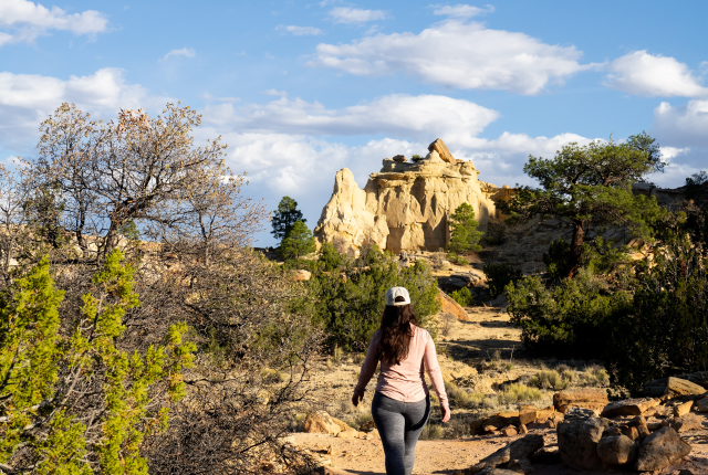
In the Ojito Wilderness, the Hoodoo Trail is dotted with many of its namesake formations.
WHEN THE 110-FOOT-LONG Seismosaurus unfurled its serpentine neck in what we now call the Ojito Wilderness Area, its comparatively compact head topped a forest of ginkgo and palm trees. In the Jurassic period, 150 million years ago, this region was a tropical paradise about 35 degrees north of the equator. Eons of continental drift and volcanic explosions would come to buckle the land. Inland oceans and rolling rivers rose, receded, and returned, each time depositing evidence of lives that time nearly forgot.
Thanks to the sharp eyes of a group of hikers in 1979, we know about Seismo, the Jurassic giant, today. A replica of its fossilized bones stands as a centerpiece of the New Mexico Museum of Natural History and Science’s dinosaur exhibit, in Albuquerque. It also serves as a mascot of sorts for the Ojito Wilderness Area and the adjoining White Ridge Trails.
Together, the Bureau of Land Management–supervised properties—located about 30 miles northwest of Albuquerque, near the village of San Ysidro—lay out a legend of geologic and cultural delights that have drawn hikers, bikers, and scientists for decades. Its San Ysidro anticline features Grand Canyon–esque layers of Technicolor rock. A clutch of hoodoos rises among ponderosa pines thriving far below their typical elevation. Evidence of Ancestral Pueblo, Navajo, and Hispano homesteads pockmark the landscape, along with petrified wood, fossils, and potsherds. Gypsum-laden mineral springs bubble up, coating ancient stone with what looks like puffy snow.
In 2005, Congress set aside most of the BLM’s holdings, 11,823 acres, as the Ojito Wilderness, with a special designation as Zia Pueblo Trust Land. The act protects it from development, as well as chainsaws, vehicles, and even bicycles. But if you’re driving along its edge, on Cabezón Road, you might wonder why they bothered. Some stretches appear mostly as desert scrub. And, taken one by one, its highlights pale next to others in the state. Far more hoodoos await at the Bisti/De-Na-Zin Wilderness Area, near Farmington. You might spy a few petroglyphs at Ojito, but nothing like the bounty at Three Rivers Petroglyph Site, near Tularosa. Its archaeological sites aren’t marked on maps, and few off-trail hikers will even recognize them, unlike those at Chaco Culture National Historical Park.
On top of all that, cattle still graze here. Hunting is also allowed, along with target shooting, though those seeking the latter activity mainly stick to BLM land outside the wilderness boundary. If hunters and shooters venture over that boundary, they have to walk in, pack out their “trigger trash,” and stay away from trails.
Still, the sum of the Ojito’s parts conjures magic. “This area had phenomenal geology, cultural history, the solitude, the lack of man-made structures,” says Jamie Garcia, a spokesperson for the BLM. “All of that came together in proposing it as a wilderness.”
The Hoodoo Trail treats hikers to big views of ancient rocks.
OJITO TRANSLATES TO “LITTLE EYE” in Spanish, which can also denote a small spring or creek. Cascades of water on this landscape long ago disappeared; what seeps out today is so laden with minerals as to be undrinkable. But its flow still helps shape the geologic gem of the White Ridge Trails: the San Ysidro Anticline, which kindled my decade-long infatuation with the area.
After ascending a short and drably colored rise from the parking area, the anticline materializes in a moment that deserves the soundtrack of an angel’s trumpet. The ancient, U-shaped monolith of banded red, green, gray, and yellow rocks extends its mammoth arms northward in a jumble of sheer cliffs, slot canyons, hidden caves, and up to 12 miles of kaleidoscopic trails.
In the far distance, to the left, the slate-blue silhouette of Cabezón, a volcanic neck, holds its waypoint, as do the ruddy slopes of the Jemez Mountains, to the right. I always pause here, rejoicing in the view alone, before the lure of farther wonders spurs me onward.
Going clockwise, the Dragon’s Back Trail climbs along the anticline’s western rim, then drops precipitously into a valley of mineral springs and cenotes. Sometimes, I continue through the eroded valley and tackle the steep return of the Central Spine or wander to the east for the more gradual elevation gain on what hikers call the dragon’s tail. (The BLM and mountain bikers call it White Ridge Trail A.)
Seeps and springs leave gypsum deposits throughout the White Ridge Trails.
“It’s just perfect,” says Larry Crumpler, a geologist at the Museum of Natural History and Science. “All the layers that make it so textbook are right there in front of the eyes, highlighting the warped layers of dino-age sediments. It’s special because there’s no vegetation to mess up the view of the whole thing.
“When I crest that rise overlooking the anticline,” Crumpler adds, “my first impression—besides how perfect it is, how colorful it is, and how ‘Southwestern’ it looks—is the geologic diversity visible from just that one spot.”
Imagine a layer cake. Slice it in half, then scoot two of the ends apart, forming a triangle in the middle. Now, press the ends of each half toward its middle to make a hump. What you accomplished in a few minutes of bakery playtime took around 200 million years of different muds, stones, and basalt to compress and then snap-crackle-pop into place, even as waters and winds nibbled them into cliffs and canyons.
Anticlines exist elsewhere, but the ease of analyzing this one draws geologists from all across the nation. Within the exposed arches, you can find evidence ranging from the Late Triassic to Early Cretaceous periods, as dinosaurs, birds, and seed-bearing plants emerged.
“This area had phenomenal geology, cultural history, the solitude, the lack of man-made structures. All of that came together in proposing it as a wilderness.”
—jamie garcia, blm spokesperson
I once interrupted a university’s geology field school on the trail, but more often I encounter other hikers and mountain bikers. Connor Rice, vice president of the Albuquerque Mountain Bike Association, began exploring the area 25 years ago as a high schooler. He still loves it—although he recommends choosing cool weather, given the lack of shade.
While hikers might find some of the hills a tad daunting, he considers them fine for competent, intermediate bikers. “It’s not terribly technical,” Rice adds. “There’s some exposure, but I don’t know of anyone who’s gone over the edge. It’s farther than you think it is.” As for the sharp descents that turn me into a fair imitation of my grandmother? On a bike, he says, “You just rip going down.”
While signage helps you find your way, it pays to download a map of the trails, given the maze of rogue routes. Garcia says the BLM tries to dissuade people from making new trails or engaging in the “trail braiding” that occurs when they dodge puddles or cacti. One reason to obey the caution: the rare Townsendia gypsophila, a small aster that grows only in gypsum soils.
You should also watch out for rattlesnakes, Garcia says, but the views more than compensate for the caution. “It feels like you’re on top of the world there,” she says. “It’s really cool.”
Zach Bryan and Susan Montoya Bryan bike along the White Ridge Trails.
ONLY AFTER A FEW TRIPS TO THE WHITE Ridge Trails did I venture into the wilderness area. Until then, I had feared the road conditions. I had fretted about the target shooters. Mainly, I didn’t know where to go.
Should you harbor similar hesitancies, relax. Barring a spate of rain or snow, Cabezón Road accommodates almost any kind of car. Two well-marked trails, each with its own parking area, deliver laid-back introductions to hikers. Do one, then drive to the other for a decent day trip.
Start at the Seismosaurus Trail. About 10 miles from US 550, its parking area is on your left. The approximately 2.2-mile out-and-back trail begins across the road from it. You’ll encounter wildflowers, gentle rises, and perhaps a few fossils before reaching a sand pit below a rocky outcrop at around 1 mile.
“It probably weighed 25 tons,” Spencer Lucas, a paleontologist at the New Mexico Museum of Natural History and Science, says of the leaf-eating Seismosaurus (Diplodocus hallorum) found there. It was blind luck that knowledgeable hikers spotted a few vertebrae. Had those bones been left to the elements, the beast’s final testament might have melted away as well.
A hiker navigates a gypsum-coated moonscape.
“Once a fossil is exposed,” Lucas says, “it’s getting damaged. The worst is the freeze-and-thaw cycle. Rock has water in it. Fossils aren’t forever once they’re exposed.”
Lucas encourages hikers to hunt for fossils as big as Seismo or as small as a shell. Federal law, however, prohibits taking them from the wilderness. “Fossils are part of our national heritage,” he says. “They belong to all the citizens of the U.S. If you pick it up and take it home, you’re damaging the rest of your countrymen.”
As rain, snow, and wind wear away the land, more fossils emerge. If you think you’ve found something significant, snap a picture, note your location, and contact the museum. Big hint from Lucas: “If you want to see something pretty new, you’re going to have to get off the trail.”
More on that soon. For now, head back to the car. Drive another mile on Cabezón Road to the Hoodoo Trail parking area. The roughly 3.4-mile out-and-back trail leads to a small string of sandstone hoodoos—eroded rock pillars sometimes topped by boulders—in layers of muted peach, rosy pink, and palest yellow.
“I love those colors against the deep blue New Mexico sky,” Garcia says. “I’m a macrophotography gal. I love the tiny details. The grandiose scenery out there is phenomenal, but when you look at these tiny details, that makes it cool.”
An old adobe cabin near the Dragon’s Back Trail.
The hoodoo area includes a twisted tree trunk that was wind-whipped into a corkscrew, bubble-like concretions of rock emerging from soft clay, and a surprising number of elevation-defying ponderosa pines. Wander around a bit, but please, Garcia says, do not clamber onto the hoodoos, no matter how awesome the selfie seems.
“You can easily damage them,” she says. “And it’s not safe. Those can easily tumble down. I see pictures on social media: They’re perched on a one-ton boulder that’s balanced on a tiny pillar of sandstone. And once the boulder falls, the pillar erodes away.”
Sorry to rob you of that bit of fun, but here’s a consolation prize: You can wander anywhere you want in the wilderness. And it’s relatively easy to confirm where you are. The BLM has worked to refine the wilderness area’s presence on Google Maps, so keep a phone handy and consult it regularly. Use some low-tech tricks as well: Take note of the cliff-topped Bernalillito Mesa west of the Hoodoo Trail. Track with your eyes to the place you reached on the Seismosaurus Trail. Remember where the road is. Heck, use the target shooters’ noise as another checkpoint.
I once continued overland from the hoodoos to cross a variety of geologic moonscapes that included an enormous heart-shaped boulder and miniature arches. I ended up at an old sheepherder’s cabin, which posed beautifully for my social-media shots. (Its array of rusty items outside sorely tempted me, but I could hear Garcia’s warning in my head: “If you see a really cool old Folgers can, have fun and explore, but leave it behind.”)
That lengthy meander through the Ojito represents one of the best uses of wilderness areas throughout the state. “What I love about the BLM,” Garcia says, “is there’s so many opportunities to wander. Just make your own adventure.”
These formations await at the end of the Hoodoo Trail.
ANYONE FAMILIAR WITH THE OJITO HASby now taken note of what I’m leaving out. I haven’t told you the most reliable places to see petroglyphs. I didn’t even hint at where Ancestral Pueblo people once lived. Where’s the “secret” cave in the White Ridge Trails? How do you get to a slot canyon? The internet holds plenty of clues. Some of them are accurate.
But archaeologists have persuaded me to avoid revealing too much. Their biggest concern is vandalism, even among well-intentioned visitors. In the company of site stewards—volunteer team members who monitor archaeological places. I’ve seen a few of these unexplored and sacred locations, marveled at pieces of ancient pottery, and wondered about the hard lives that were eked out in a harsh place. I’ve hiked to a few petroglyphs, puzzled over their meanings, and opted to leave the interpretations to the makers and their descendants.
The most I’ll do here is confirm these places exist. You might find them. If so, appreciate your good fortune, take pictures, soak in the atmosphere, and leave everything the way you find it. The journey will fill your head and heart.
These joys keep pulling me back to the Ojito. Wander long enough, and even the stretches that appeared as wastelands turn into sinuous arroyos filled with captivating specimens of the living (lizards, birds, flowers) and the dead (fossils, lots of fossils).
On a recent trip, I ventured into the Ojito’s western reach, where I scared off a few cows before settling atop a red-rock escarpment overlooking the breadth of the region. From my perch, I admired the way a nearby pillar and an adjacent cliff held a boulder, trapping it high in the air. Someday, it will fall, I thought. Maybe in my time.
But the rest will endure—the land that holds stories of interior seaways, ancient volcanoes, and people who called this place home. All of it will remain. Yours for the exploring. Our nation’s gift for generations to come.
During her visit to the Albuquerque Bureau of Land Management office, Kate Nelson purchased an armload of maps for future hiking adventures.
OFF THE BEATEN PATH
Get prepped for a remote adventure in the Ojito.
Drive there: Cabezón Road is off US 550, about 21 miles northwest of Bernalillo and two miles south of San Ysidro. Take the left fork; the right goes to a gypsum mine. The main parking lot for the White Ridge Trails is 4.4 miles in; the Seismosaurus and Hoodoo trailheads are roughly 10 and 11 miles. Gasco Road, just west of the White Ridge lot, is open for horse riders.
Study up: Go to nmmag.us/rpfo-kiosk for information about the Ojito Wilderness Area and the White Ridge Trails. The page includes links for trail brochures for each. The New Mexico Bureau of Geology and Mineral Resources explains more about the San Ysidro Anticline at nmmag.us/anticline.
Be smart: Cabezón Road is well-maintained, but heavy rains might require high-clearance, four-wheel-drive vehicles. There are no bathrooms or water sources. Pack it in and pack it out. Beyond a few picnic structures at the White Ridge Trails, shade is elusive. Choose cooler mornings and evenings.
Keep a lookout: If you find archaeological sites that seem significant, or show signs of vandalism, call the Bureau of Land Management at 505-761-8700. Report fossil discoveries to the Museum of Natural History and Science at 505-841-2800.
Show respect: Outlying stretches of Zia Pueblo surround the Ojito. Do not trespass onto them.