
Above: Family members hike up the manmade volcano on Albuquerque's west side. Photograph by Tira Howard.
IN HER NEWEST BOOK, Secret Albuquerque: A Guide to the Weird, Wonderful, and Obscure (Reedy Press), longtime New Mexico Magazine contributor Ashley M. Biggers digs into 90 places that most tourists and even many residents have never seen. The book includes tales of spies, the legacy of comic-strip cowboy Red Ryder, and where to find Walter White’s grave marker. We picked a few of our favorites that are free to visit and open to the public. (Hiking boots and model boats optional.)
Go with the Flow
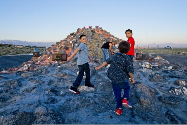
The volcanoes that frame Albuquerque’s west side are known as the Three Sisters, but there’s a fourth “volcano” on that horizon. The Albuquerque Metropolitan Arroyo Flood Control Authority built it as part of a water diversion project in 2017. Although it may fall short of full-on art, it is more exciting than the gray concrete channels that dominate the city’s flood control efforts.
Because the neighborhood is already home to extinct volcanoes, the board thought a volcanic cone would be fitting. When the Duke City receives rain, water floods down the volcano’s sides, sluicing through channels lined with black and orange rock to make the water look like lava. When the volcano reaches full flow, it shoots water six feet in the air in a true eruption.
Lights add to the illusion, and their colors shift seasonally. On a normal day, the lights slowly cycle through an array of colors, but they glow red and green at Christmas; red, white, and blue on the Fourth of July; and a lucky green on St. Patrick’s Day.
The volcano serves a practical purpose as well: It oxygenates the water so that when it flows into the Río Grande, it creates a healthier environment for fish, including the endangered Río Grande silvery minnow.
Where: The volcano is visible from the westbound I-40 off-ramp at 98th St.

Above: Feeding ducks and geese is a popular activity at Tingley Beach. Photograph by Tira Howard.
Just Beachy
In 1931, the stretch of land between the Albuquerque Country Club and the Río Grande was a former city dump. Mayor Clyde Tingley, who served in elected office for some 40 years, envisioned a new identity for this acreage. He instructed the newly formed Middle Río Grande Conservancy District to dredge the dump and install a shallow lake. Conservationist Aldo Leopold’s 1917 design for a Río Grande Park, which included a lake, may have inspired Tingley.
Then called Conservancy Beach, its waters were large enough for the speedboat races that took place there on weekends in the 1930s. The lake’s waterslides, diving platform, bathhouses, and miles of shoreline for sunbathing immediately became a draw. It remained a popular outdoor swimming pool until the 1950s, when polio scares closed it to swimmers.
Read More: Check out these natural (and free!) urban adventures in Albuquerque.
Decades later, the U.S. Army Corps of Engineers and the City of Albuquerque teamed up to create fishing and model boating lakes. The last of the three lakes reopened in 2006. Anglers line the shores, and the Duke City Model Yacht Club operates a fleet of remote-controlled vessels on these waters. Tingley and his wife, Carrie, are memorialized in bronze statues on the western edge of Tingley Beach.
Although fishing is free, you’ll need a New Mexico fishing license. When you’re done fishing, hop aboard the railroad that chugs to the other three ABQ BioPark destinations—the zoo, aquarium, and botanic garden.
Where: 1800 Tingley Dr. SW, off the Paseo del Bosque Trail.
 Above: "Fossils" line an arroyo’s walls. Photograph by Tira Howard.
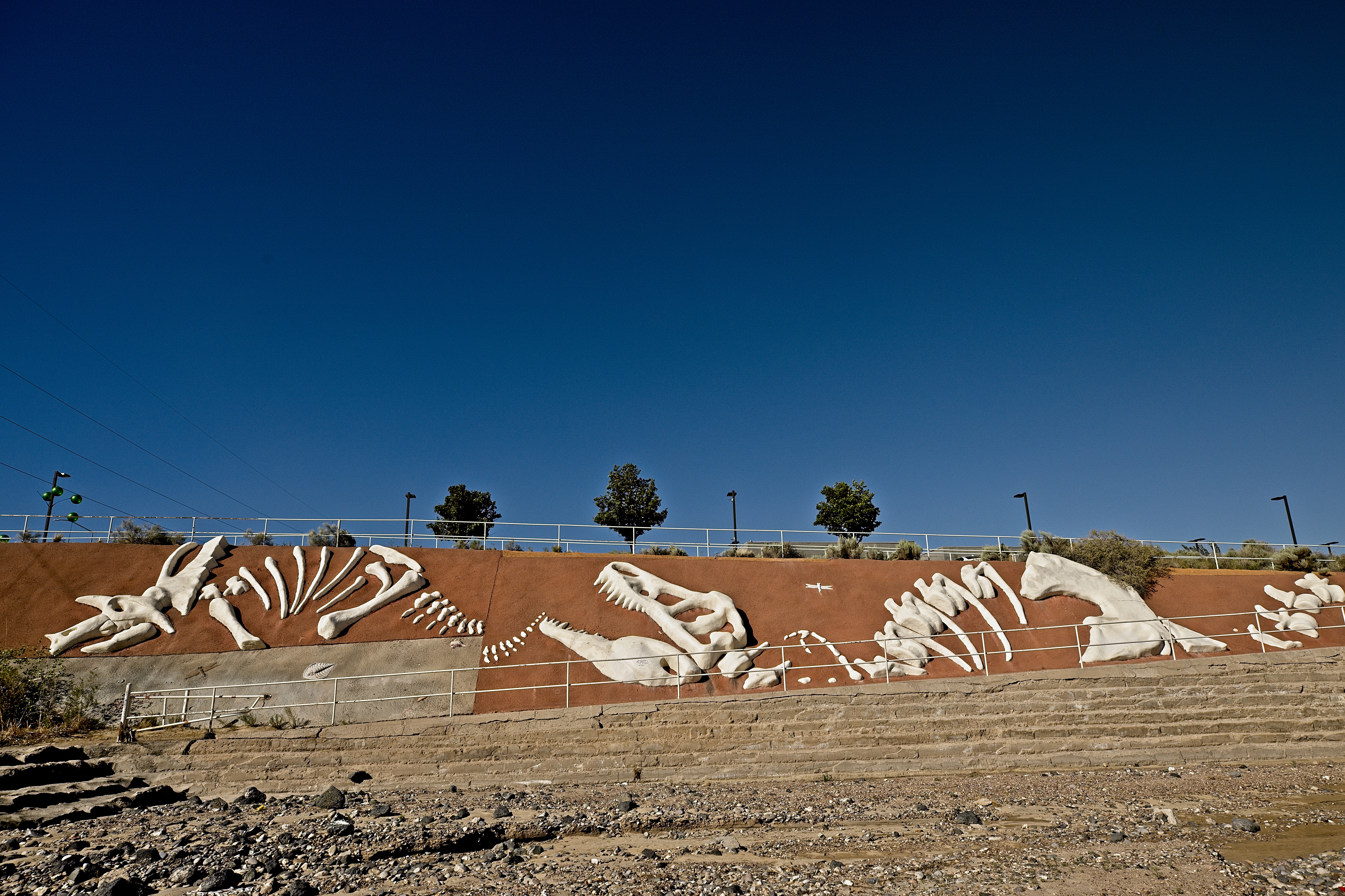
Fossilized
In 1998, an arroyo (water drainage channel) project became a work of art. After the Albuquerque Metropolitan Arroyo Flood Control Authority completed its construction work on the Calabacillas Arroyo, artist Michael G. Wallace cast artificial fossils in the channel walls.
“It was going to be in a populated area, so we thought, Let’s make it look good,” says Kevin Troutman, an AMAFCA manager. As the largest arroyo on the city’s west side, Calabacillas extends 17 miles, but the fossils can be found in the portion just east of Coors Boulevard. In that section, white forms depict a variety of objects from New Mexico’s history, from the Precambrian era to the future, which is represented by the footprints of a baby.
The fossils look as though they are embedded in rock layers, with occasional strata and faults denoting eras. Forms trickle down the channel’s north and south sides. The largest and most eye-catching of these (even occasionally from Coors Boulevard) is known as the “Arroyosaurus,” which looks like the skeleton of a Tyrannosaurus rex.
This predator is followed by the bones of a saber-toothed cat and a mammoth. The forms become more modern as they flow east. They depict a conquistador helmet (marking the arrival of the Spanish), a wagon wheel (the advent of the Santa Fe Trail), and the “Fat Man” nuclear bomb (the arrival of the Atomic Age), to name a few.
Where: From Coors Blvd. (north of Paseo del Norte), turn east along Westside Dr. NW. Follow that road downhill. Before it turns south and becomes Riverfront Road NW, there is a parking area to the left (north) and walking paths on both sides of the channel. Keep in mind that in times of rainfall, ditches are deadly and should be avoided.
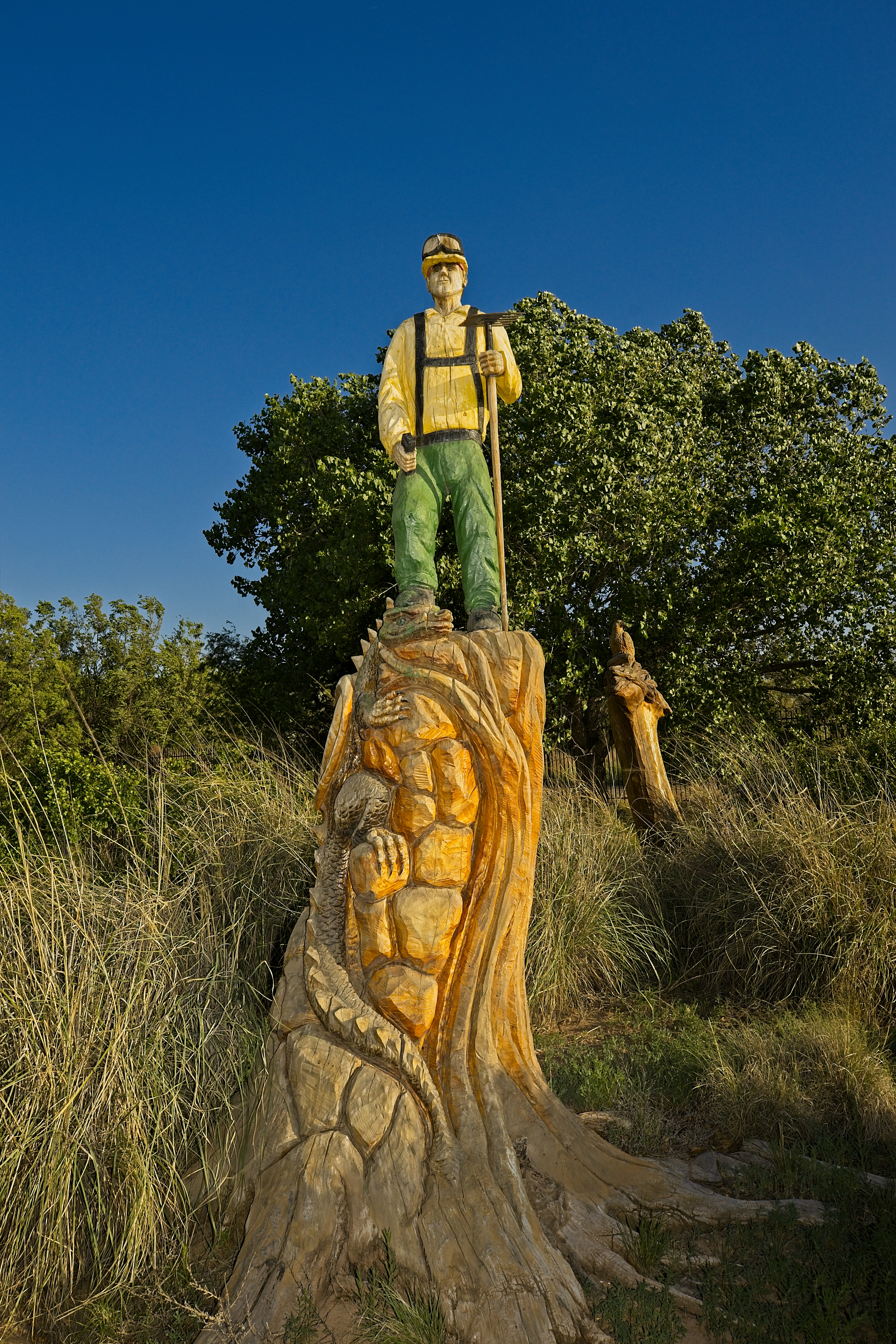
Above: A firefighter sculpture in the Río Grande Bosque. Photograph by Tira Howard.
I Sawed That
Firefighter Mark Chávez has transformed fire-scorched acreage in the Río Grande Bosque into a destination. In 2003, teenagers sparked a fire in the riverside cottonwood forests while playing with fireworks. The blaze roared through the trees, burning between 100 and 250 acres along the Río Grande.
Chavez helped fight the fire, then turned to his hobby to leave another lasting mark on this place. A self-taught chain-saw artist, he set to work turning 10 dead trees into rough-hewn sculptures dedicated to local wildlife, Southwest culture, and the firefighters. Sculptures in the garden depict a bald eagle rising from flames, coyotes howling, and herons, squirrels, and turtles.
Two sculptures have symbolic significance. One depicts La Llorona, a famous figure in Latin American and New Mexican folklore who wanders the river calling out for her dead children—and snatching children wandering alone. Another sculpture pays homage to firefighters, with the proud figure of a fireman standing on a defeated dragon. Chavez is now retired from firefighting and works exclusively on his art through Sandia Bear Company.
Where: Pueblo Montaño Picnic Area and Trailhead, 4100-4112 Montaño Road NW.
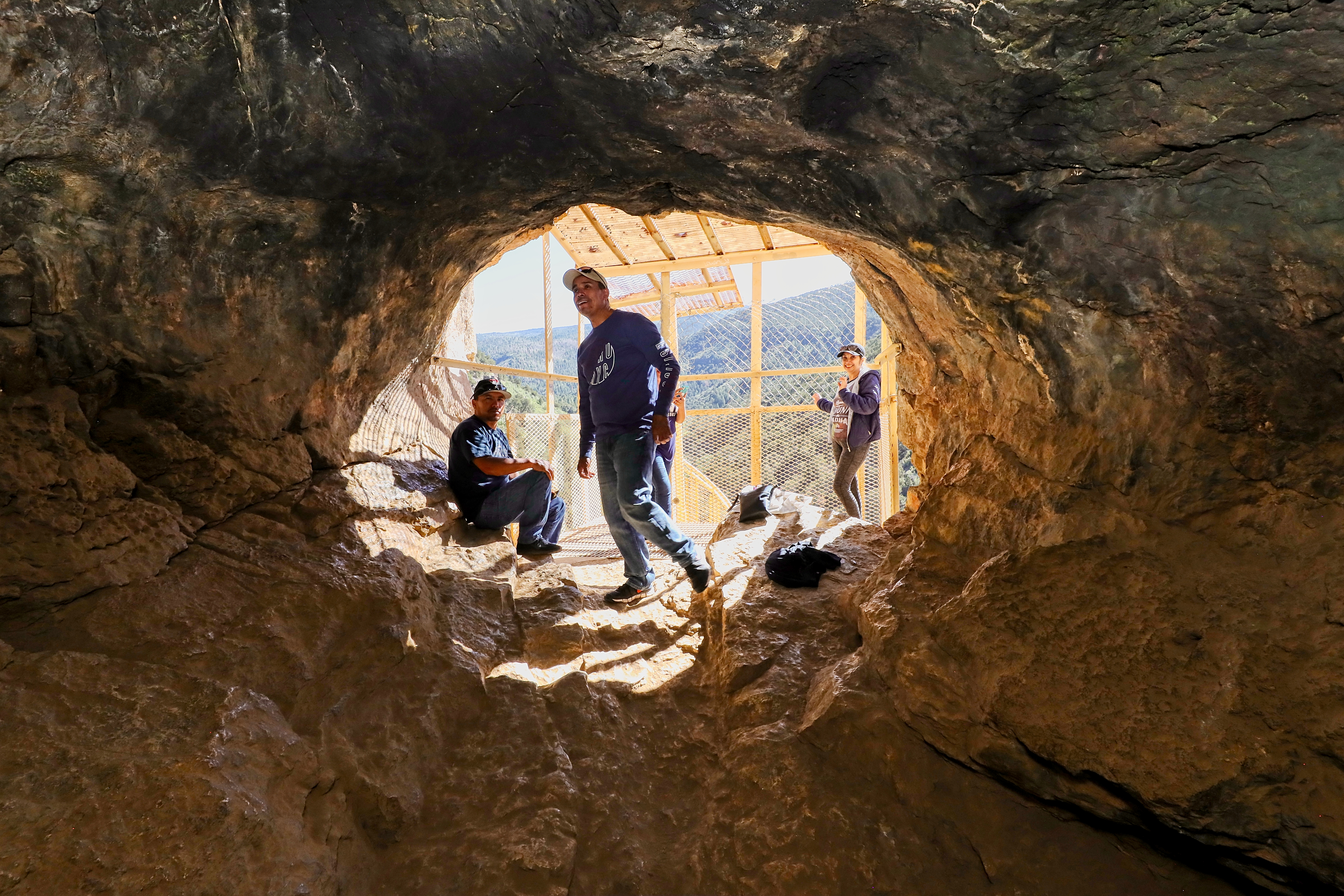
Above: A peek into Sandía Man Cave. Photograph by Tira Howard.
Anthro Apology
Perched high on a cliff above Las Huertas Canyon in the Sandía Mountains, a cave led to evidence that people lived in North America thousands of years earlier than archaeologists had previously thought—at least that’s what archaeologist Frank Hibben claimed when he excavated the cave in the 1930s.
As he dug through the strata, he found evidence of the previously recorded Folsom culture, Paleo-Indians who lived in what is now the southwest United States 10,000 years ago. At the time, archaeologists believed them to be the Americas’ earliest inhabitants. Beneath that layer, however, he found something that turned archaeologists’ heads: evidence of a chipped stone spearhead and animal bones. Dubbing the group of people who left them behind “Sandía Man,” he estimated that these big-game hunters lived in the Southwest approximately 25,000 years ago. When Time magazine reported the discovery in its May 1940 issue, the coverage cemented the discovery—and Hibben himself—as revolutionary.
Read More: Albuquerque’s Bosque Trail is the best way to explore the city—and get away from it.
However, as other archaeologists sought to substantiate his claim, they found inconsistencies in the samples. Disturbingly, some suggested that Hibben had planted the unique flint in the cave. Hibben seemed to skirt the controversy. He continued teaching at the University of New Mexico and overseeing the Maxwell Museum of Anthropology until his 1975 retirement. However, in 1995, journalist Douglas Preston, a Santa Fe resident, published a damning account of Hibben’s research in The New Yorker, which led to researchers largely erasing the discovery from archaeology textbooks.
Reaching the cave itself involves a bit of a high-wire act: A circular staircase leads to a three-sided cage built onto the cavern’s entrance. While the public is welcome to climb up and enter the cave’s first room, venturing far beyond it is discouraged.
Where: The Sandía Man Cave is located on the north end of the Sandía Mountains, off NM 165. (The road is dirt and can be rough.) The parking area is marked with a sign. It is a 0.47-mile hike from the parking area to the staircase.
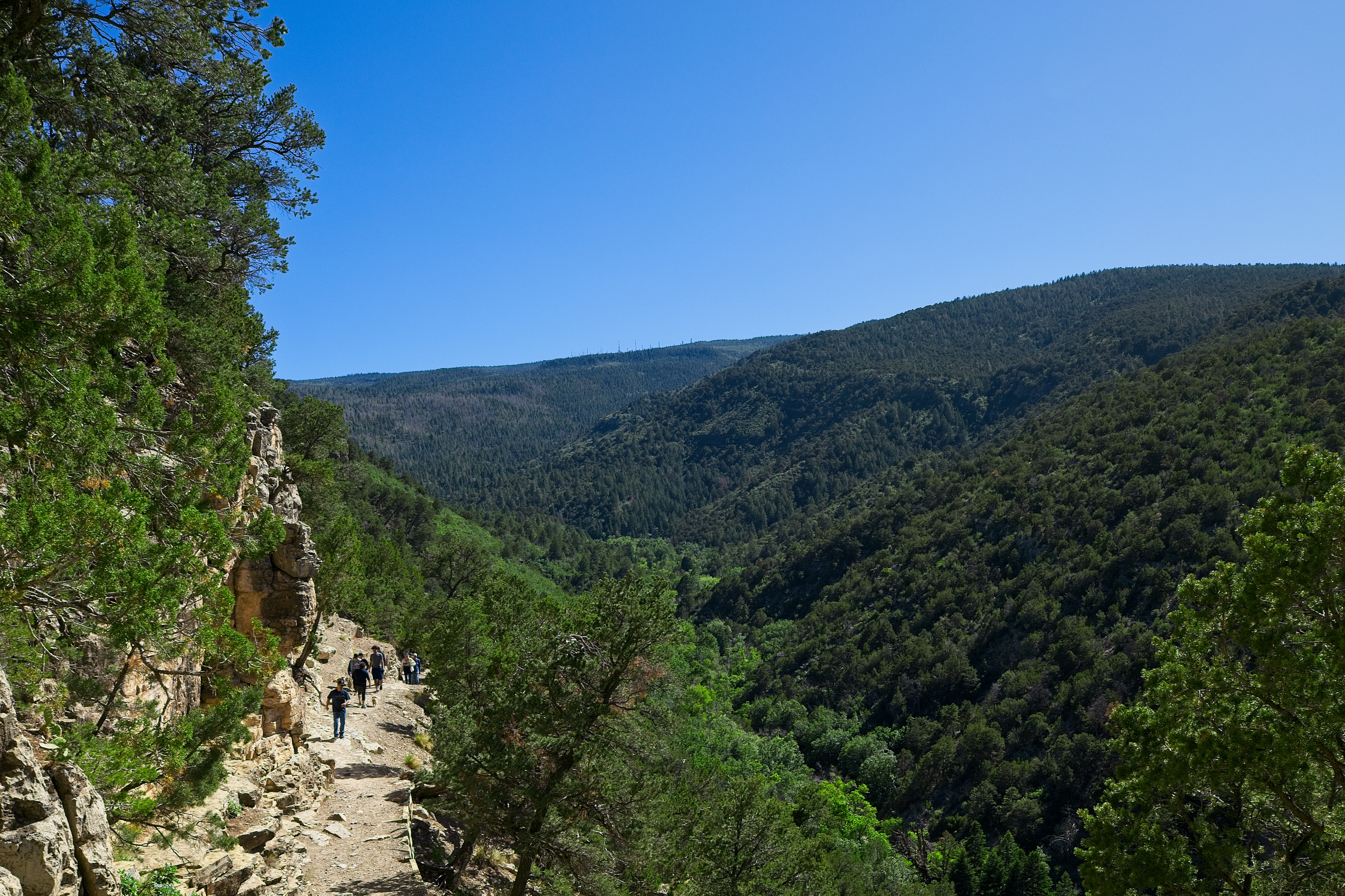 Above: A forest view along the trail to Sandía Man Cave. Photograph by Tira Howard.
Somebody’s Watching You
The Eye of the Sandías—a mural on a boulder—is known among those who frequent Sandía Mountain trails, but is an eye-catching discovery for others. An anonymous artist painted the quirky three-by-three-foot landmark sometime in the 1960s. Other people touched it up over the years.
It looks a bit like the Egyptian Eye of Horus, which symbolizes protection, power, and good health. A Zia, the symbol of New Mexico, sits in the pupil’s center, and tears drip from the corner. Urban legend suggests that the eye represents the mountain’s sadness at the city’s encroachment.
Reaching the eye requires a 3.8-mile round-trip hike, which gains around 1,200 feet in elevation going in. The trail is rated moderate to difficult, depending on the source. The final climb to the eye is quite steep. From its vantage, you overlook Tijeras Canyon to the south and the entirety of Albuquerque to the west.
Where: The hike departs from a parking lot at the eastern terminus of Copper Ave. Precise trail directions are available online and in area hiking guides. This is an exposed trail; pack plenty of water.

GET WEIRDER
Purchase a copy of Secret Albuquerque: A Guide to the Weird, Wonderful, and Obscure, by Ashley M. Biggers, at ashleymbiggers.com/shop.