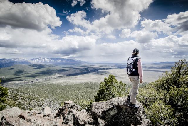
Rasa O’Donnell surveys the Río Grande Gorge from Cerro Chiflo.
MY WIFE SEES IT BEFORE I DO.
As we mount the cerro in silence, wind hisses across the sage and rocks and into the piñon and juniper. Above, ravens and vultures play on rising thermals. Below, pinyon jays careen through the sage, laughing in a high-pitched “caw-a-a-ahhh.” The ground is broken and uneven, dark basalt fractured into sharp edges that shift underfoot.
Below and to the east, the Río Grande cuts through the land in a scar so deep it doesn’t seem possible. The gorge is less canyon than absence, something removed from the earth rather than carved into it by water. From our 900-foot perch on the cerro, the river appears a shining ribbon of mercury through shadowed rock, forever exerting its presence. Some call this place the Empty Quarter, perhaps 15 miles south of the Colorado border and 20 miles north of Taos in the Río Grande del Norte National Monument. There are no trails out here.
Rasa, my life partner and adventure companion, kneels into the dirt and takes the tool into her palm. “That’s not natural,” she says. As a trained field archaeologist, I instantly recognized it as a quartzite drill, a T-shaped stone tool designed for piercing bone, shell, wood, and hide. Because quartzite is exceptionally hard and durable, ancient people selected the stone for tasks demanding a high resistance to wear. Dating stone artifacts is notoriously difficult. The drill could be 500 years old. It could be 5,000 years old.
The Río Grande flows through the Wild Rivers Recreation Area, near Questa.
I turn the tool between my thumb and forefinger. There is likely no one else within 10 miles of us. Yet the land does not feel empty. The loose basalt, the ravens, the river, the gnarled junipers, the endless blue, the drill. The Taos Plateau conveys a persistence that renders our presence temporary, accidental even. I dig a pit with my fingers and place the drill into the hole, covering it with soil. As a value, Rasa and I don’t collect anything we find. These things belong to the land.
Taos archaeologist Tom Dillehay has written about how “landscape knowledge” accumulates through generations of repeated use. In this view, land and memory are inseparable, part of a long and unbroken engagement that continues to this day.
We mount the cerro with care. There is nothing about this place that is new. At an average of more than 7,500 feet in elevation, the Río Grande del Norte National Monument covers 240,000 acres of the vast Taos Plateau northwest of Taos. The monument sits within the Río Grande Rift, where the earth’s crust is pulling apart. Over millions of years, the land between parallel faults dropped, birthing a wide basin stretching from Colorado to Texas. The monument protects a landscape where geologic forces, wildlife movement, and human presence converge. Designated for its significant natural, cultural, and scientific values, it safeguards critical habitat, archaeological sites, and a river system that continues to shape the land. The monument designation preserves not just scenery, but an intact, living system forever in motion.
You understand the vastness of it all in fragments. A scatter of stone flakes where someone shaped a tool. The faint remains of an earthen wall pressed low to the ground. And on this trip, the petroglyphs we are hunting for on the cliff face above. The signs appear and disappear. They are easy to miss unless you seek them out. Even then, they resist. This is what draws me to the Taos Plateau—and keeps me coming back.
Ancient petroglyphs can be found along the Río Grande.
THIS IS A LAND BORN DEEP IN EARTH’S forges. Beginning roughly five million years ago, a series of basaltic eruptions spread across the region, sluicing lava outward in broad sheets. These flows cooled into the dark volcanic rock that is the hallmark of the monument.
What appears to us today is but the latest in a deep-time process. Beneath the basalt lies older sediments, ancient river deposits, volcanic ash, cinder cones, and uplifted material from a landscape born long before the plateau itself. The river followed, rushing meltwater through fractures in the basalt, eroding zones of softer material. Current research suggests the deep incision accelerated only after the San Luis Basin spilled billions of gallons of glacial melt south. The modern river system may only be about 400,000 years old. Far from a completed masterpiece, the Río Grande continues to deepen spring flow by spring flow.
“Hundreds of springs still nourish the Río Grande,” says Paul Bauer, emeritus principal geologist at the New Mexico Bureau of Geology & Mineral Resources. “The springs collectively provide about 55,000 gallons per minute of fresh water to the river. During times of drought, most of the flow of the Río Grande through the monument is due to the springs.”
“Hundreds of springs still nourish the Río Grande. ...During times of drought, most of the flow of the Río Grande through the monument is due to the springs.”
—geologist paul bauer
The plateau is anything but flat. From the slopes of the cerro, vast grasslands and sagebrush mesas stretch outward, broken by forested volcanic edifices—Cerro Chiflo, Cerro del Aire, Cerro Montoso, Cerro de la Olla. Near the Colorado border, Ute Mountain rises to 10,093 feet. These features, known locally as cerros, formed when molten rock erupted at the surface, building steep-sided hills and mountains of dense lava that were later exposed by erosion.
“The rift basin is considered the largest high-elevation valley on Earth,” Bauer says. “The monument holds the most diverse volcanic landscape in the Río Grande Rift. At least 40 distinct volcanic vents have been identified on the plateau, and most are within the monument.”
During the colder, wetter millennia of the Pleistocene, water held longer across the plateau, forming shallow lakes and moving through channels that have long since faded. At one time, vegetation was thick with grass and spruce-fir forests. The grass, sage, piñon, and juniper that remain mark a thinner version of what once existed. What we see today is only the latest expression of a place forever in flux. Wet to dry. Cool to warm. Each change depositing traces that are not always visible but never gone.
The Río Pueblo de Taos flows through the Río Grande del Norte National Monument.
Three to five million years ago when the land cooled, life returned.
Across the broader Taos Plateau, the remains of mammoths and other Pleistocene megafauna have been found, souvenirs of that colder, wetter landscape when forage was more abundant. In more recent times, coyotes, mountain lions, wolves, and grizzly bears came to know the plateau as home. By the river, bighorn sheep, beavers, and otters thrived.
And birds. The national monument lies along what is now called the Central Migratory Flyway, essentially a highway for birds. Sandhill cranes, with a fossil record stretching back 2.5 million years, cross the plateau each fall and spring on a timetable older than the gorge itself. Eagles, falcons, and hawks make the basalt walls their nesting homes. Osprey, herons, ducks, merlins, willets, and more all came to settle in the area.
The pronghorn lineage evolved in North America roughly 28 million years ago, shaped by the evolutionary forces of predators long since extinct. Elk, bighorn sheep, and mule deer move through this country as well, following seasonal patterns tied to elevation, water, forage, reproduction, and the avoidance of predators. This is a big, wild place.
Hot-air balloon flights are a spectacular way to get to know the monument.
WE SCRAMBLE OVER SHARP BASALT dressed in orange and baby-blue lichens that evaporate to dust under my fingers. Somewhere here, along the south-facing flank of the cerro, stands a petroglyph. I’d seen it in a friend’s photograph. The rock art images were precise, carved skillfully into a black basalt face. It stayed with me. Not as much for its detail but as a witness to life on the plateau thousands of years ago.
The climb is steep and uneven, rock shifting underfoot. “Ankle breakers” we name this type of hike. We know from experience, so we are cautious. The wind falls away as we move off the edge and up into a stand of oak. The land wraps itself around us, giving shelter.
Archaeologists working across northern New Mexico and southern Colorado have long pointed to the continuity of movement. People have traversed the Taos Plateau for at least 20,000 years and likely much longer. Members of the Taos Archaeological Society have documented thousands of sites: trading and travel routes, hunting overlooks and blinds, workshops, temporary settlements, places of brief use and repeated return.
“Taos Plateau is the birthplace of the Taos and Picuris pueblos and contains the homes, landscapes, and sacred sites of Pueblo, Jicarilla Apache, Ute, Navajo, Comanche, and earlier gatherer-hunter groups,” says Paul Reed, the New Mexico state director and preservation archaeologist of Archaeology Southwest. “The history of greater Taos reveals itself to those who are willing to walk its mountains and valleys.”
Soak by the riverside at Manby Hot Springs.
THE RÍO GRANDE DEL NORTE NATIONAL Monument was established by presidential proclamation in 2013, protecting more than 240,000 acres of public lands managed by the Bureau of Land Management. For years before that, the region existed in a sort of purgatory of land management known to ranchers, hunters, hikers, and anglers, but largely overlooked by the general public.
Efforts to protect the area grew from that familiarity. Local communities, tribal governments, conservation groups, ranchers, and outfitters all recognized both the ecological and cultural importance of the landscape. The monument designation, made under the Antiquities Act, was less about changing the land than acknowledging what was already there.
“The intention was not only to conserve the land itself, but to protect access to ensure that these long-standing relationships between people and place could continue,” says Ben Mortensen of the Friends of the Río Grande del Norte, a Taos-based nonprofit that works to connect Americans to their public lands through educational opportunities, tours, and stewardship projects. “Conservation and community are not separate things here.”
Rocky Mountain bighorn sheep have made a comeback in the gorge.
We come in along the unavoidable rim of the gorge. The river is a glinting green ribbon hundreds of feet below. The depth of the gorge never fully resolves visually.
There are a multitude of pathways into the monument, none complete on their own. Be it by foot, bike, horseback, or water, each approach reveals a unique version of the monument. To understand it better, you must go down.
We descend along the Big Arsenic Springs Trail, one of a handful of routes dropping from the plateau into the gorge. Steep and exposed, it carries us from the wind to a stillness wrapped in the powerful, echoing symphony of rushing water, cold and fast, careening through basalt walls and vaporizing itself on water-carved stone. A canyon wren’s call reverberates along the expanse. A spring bubbles from the rock.
For many, the most direct way to experience this scale is by boat. Protected as a Wild and Scenic River, the Río Grande runs through the monument in lengthy stretches of white water. From the more accessible Racecourse south of Taos to the remote and demanding Taos Box, boaters in raft, paddleboard, or kayak move through the gorge at the pace of water.
Many climbing locations can be found, including near John Dunn Bridge.
Fishing follows a similar rhythm. Anglers work the banks and eddies for trout and pike, reading currents shaped by the same forces that carved the gorge.
Birders flock to the monument, seeking bald and golden eagles, peregrine falcons, hepatic tanagers, and northern pygmy owls, while autumn hunters track elk, deer, and pronghorn.
For us as Taoseños, the monument is an easy escape, reachable within an hour or so drive. We keep our truck prepped with camping gear and head out any chance we get. By the time camp is set and a cold brew enjoyed, the light falls and another layer emerges. The monument’s distance from development leaves the night sky intact. Stars settle without disruption, the horizon fading until it disappears entirely. During summer monsoons, we enjoy a star-studded 360-degree view of lightning storms. While astrophotographers map the Milky Way deep in the night, ranger-led programs offer guided walks and night sky interpretive programs as a way into the soothing darkness.
There is no single way to experience this place—only different paths that, over time, become a map of your own as you come to comprehend the immensity.
Kayakers navigate Class I and II rapids in the Río Grande’s upper gorge.
AS WE NEAR THE SUMMIT, THE AFTERNOON sunlight angles, gathering reds and yellows and oranges. From the top, the view opens in every direction, basalt stretching outward, the gorge below, river still mostly hidden. Distance flattened and expanded at the same time.
We find the petroglyphs just below the peak, etched into a dark face of rock. A line of bighorn sheep moves across the surface. Next to them, the image of a bear claw marks the stone. A spiral. And what may be a pronghorn. Off to one side stands a small Christian cross, cut later, but now part of the same surface.
Rasa kneels and opens her bag. She swallows half her water, then pulls out a pouch of tobacco. As is her habit, she deposits a pinch of the dried leaves at the base of the rock face and offers a prayer of gratitude. We sit, light shifting across the rock in such a way that I feel the bighorn move, held by stone, not explained, never abandoned.
WILD AT HEART
Get your blood pumping or reward your efforts at these spots.
Do. Start at Wild Rivers Recreation Area north of Questa, where the Bureau of Land Management maintains overlooks, campgrounds, picnic areas, visitor facilities, and trails above the confluence of the Río Grande and Red River. South of Taos, the Taos Valley Overlook offers hiking, biking, and horseback riding trails near the gorge rim. Book a guided rafting trip on the thrilling Racecourse rapids or the more technical Taos Box with Far Flung Adventures, Kokopelli Rafting Adventures, Los Rios River Runners, or New Mexico River Adventures. Hire a guide from Taos Fly Shop to fish the Río Grande for trout and northern pike. See the monument from above with Rio Grande Balloons. Watch for bighorn sheep, elk, pronghorn, raptors, and waterfowl. Check the BLM and Friends of the Río Grande del Norte calendars for guided hikes, stewardship events, lectures, and night-sky programs.
Eat. Before heading into the monument, grab breakfast at Sol Food Market & Café, in Arroyo Seco, where locals linger over huevos rancheros and thick slices of decadent carrot cake. Closer to Taos, reward yourself with a relaxed, local breakfast or lunch at Farmhouse Cafe and Bakery, in El Prado. Don’t head into the monument empty-handed. Stock up at Midtown Market & Spirits, in Arroyo Hondo, a beloved roadside stop for sandwiches, snacks, beer, and last-minute supplies. Post adventure, drop into the Wildcat’s Den, in Questa, for classic green chile cheeseburgers, crispy fries, and small-town New Mexico comfort food.
Stay. Camping is the best way to experience the monument, and the BLM manages campgrounds at Orilla Verde and Wild Rivers recreation areas, offering developed sites near the gorge and more primitive options on the plateau. For something more comfortable, try Hotel Luna Mystica on the open mesa northwest of Taos, a collection of restored vintage trailers and campsites that place you directly under the same wide sky. In Taos proper, El Pueblo Lodge is known for its elevated motel experience.