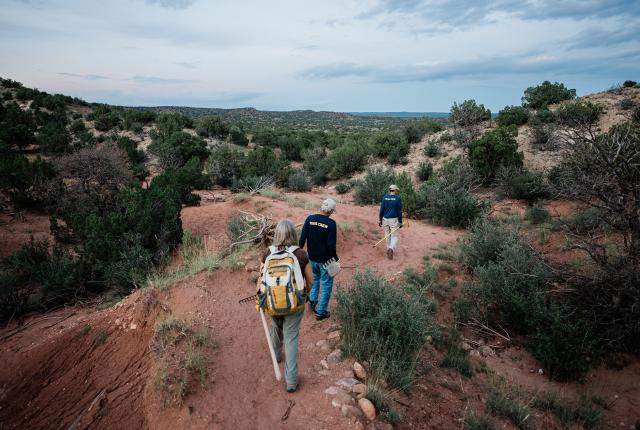
ON A SUMMER AFTERNOON IN 2021, Peter Olson guided me out to some of the newest trail loops in the Galisteo Basin Preserve. But we had to walk before we could really ride. After briefly pedaling down a dirt road, we pushed our mountain bikes through a sandy drainage, then picked up something resembling a rideable path. Olson, one of the volunteer trail builders in the rolling 10,000-or-so-acre expanse, a half-hour drive south of Santa Fe, intended to put me to work.
We coursed through piñon and juniper trees and over knolls and petite mesas that looked down into an arroyo; we threaded through knobs of blush sandstone and strips of clay that spattered our bike frames and stuck to our tires. Some of the path was just beaten-down grass, the bumpy way forward still marked with pin flags tilting in the breeze.
Out in what seemed like the middle of nowhere, silhouettes of people moved on a hill. Other volunteers had propped bikes against junipers and retrieved tools from where they’d been “banked” in the brush, left in the faith that no one needs a rake badly enough to hike a dozen miles for it. The handle of the Rogue hoe that Olson passed to me was gritty with a line of mud from the last rainstorm.
Read more: The Galisteo Basin Preserve has 50 miles of hiking, mountain-biking, and equestrian trails.
He gave me a short safety talk: The Rogue is part rake and part hoe, best carried with its squared metal points facing down, to avoid a trip into the tines and a sucking chest wound. The hoe side severs root balls, the rake drags aside loose grass and rocks, and the flat face tamps down dirt.
With almost more people than tools, progress bounded along. Soon we were hiking our bikes, tools balanced atop the handlebars, searching for places that needed more digging. That digging could widen or shift the trail—a little father around a juniper, more directly toward a rock ramp—or flatten a stable shelf that wrapped around a hillside.
Gretchen Grogan and Henry Lanman work on a trail.
Few other cyclists had ever been here. When trail builders create a new route, often the last section finished is the piece connecting the new miles to the rest of the system. The approach deters exploring bikers, hikers, and horse riders from heading out into dead-ends or unfinished work.
Raindrops reached us after about two hours. Random plinks picked up steadily until Gretchen Grogan, project and trails manager for the Commonweal Conservancy, which owns and manages the preserve, said to call it a night. Lightning spiderwebbed over the dark bloom of the storm surrounding us, opening a brief crack in curtains of rain shielding views of the Sangre de Cristo and Jemez mountains that ring the skyline. The Ortíz Mountains, to the south, lay close enough that when I paused between swings of the hoe, I watched clouds charge uphill, snag in pieces among the peaks, and waft away in white bits. We rode the barely-there trail back to our cars, arriving damp, spattered, and laughing.
Before 2003, this acreage was privately owned and stood as a potential dream destination for outdoors enthusiasts. When Commonweal announced they would acquire it that year, it might have seemed like a green light for adventurers. But trails need to be both safe and challenging. They need to respect archaeological sites and fragile ecologies. That takes time, people, and money. Just saying “go play” could have been disastrous.
Read more: The Santa Fe Canyon Preserve shelters beavers, frogs, trees, and hikers.
Read more: Take your experience to new heights on these bird-friendly hikes.
Today the preserve’s 43 miles of trails climb and trace ridgelines, meander through grassy meadows, hug the corners of juniper-spotted hills, and explore a landscape of rose-and-cream-streaked sandstone bluffs and sandy arroyos. All but the first 12 miles were built by volunteers, a growing and massive testament to what a few dedicated people can get done on the ground. Trail building had been minimal since a first flurry of work around 2006 to 2008. Then, in 2012, Grogan heard from a manager at REI that the company was offering trail-building grants. That money re-energized trail creation at the preserve—and the store manager is honored in the trail segment named “Bob Was Here.”
“Most every year since then, we’ve been either maintaining or trail building,” Grogan says. “Part of Commonweal’s mission is to get the public out onto the preserve, in all of the different areas of the preserve. It’s just such a beautiful place.”
Volunteer trail builder, Peter Olson with his dogs.
THE WORK OF CREATING A NEW TRAIL can be cumbersome. It starts with poring over topographic maps. Grogan talks with crew leaders Brent Bonwell and Henry Lanman about geographic details in the trackless parts of the preserve, thinking about where to go next and how to connect to existing trails. Once the line is roughed out on a map, they “ground truth” the idea, walking it to scout what might be most fun to hike or bike, ways to visit interesting rock features, and which hilltops snag the most impressive views.
“We’ll say, ‘Oh, yeah, this is where we thought it would go, but it would be much more interesting if we went over that way,’ ” Grogan says, “Or ‘We really can’t build a trail here, because it won’t be sustainable.’ ”
They then dot the trail into place with pin flags, marking possible points on a curve so the trail will feel organic rather than straight-lined. When that’s settled, they hike the route again, with an archaeologist who surveys for sensitive sites and other traces of people who passed through the basin for millennia, hunting, farming, and interacting with the landscape. If they find anything, the trail is moved to shield the site from traffic and theft (both have been problems). Almost every trail has been adjusted at least a little. Bonwell says he tries to forget what they find; it’s safest if no one knows what’s there.
Read more: Krystyna Gonzalez helps inspire others to lace up their hiking boots and get outside.
Read more: These three hikes are a great way to experience the dunes and all they have to offer.
Once the route is settled, someone puts in the first round of “tread.” Often, that means Lanman or Olson hops on a dirt bike to crawl along at 10 miles per hour on a wildly bumpy outing, jostled by root balls and rocks through meadows where tires can chew up the grass to help the trail take form. Chainsaws trim tree branches to provide clearance six feet wide and eight feet high for horseback riders. Then the work with hand tools begins to shape the trail edges. Most of these trails are what bikers call “singletrack,” just wide enough for traveling single file.
At some point, what a new trail needs is people. Bikers and hikers “bed down” the surface, their feet and tires packing the dirt. Those early visitors find a fairly rough ride.
“When fresh, it’s woo, buumpp, bu-bump-bu-buummp,” Bonwell says. “That’s part of the deal. It just takes some time.”
I rode the five-mile Jax’s Jaunt and Brent’s Bon Temps loop with a friend shortly after the trails appeared, rolling over trampled grass and loose sand. The route had seemingly materialized off the side of a favorite route, and we decided to spice our morning with a dose of adventure, diving off into unknown mileage and unventured terrain.
“This is like sight-reading music,” my friend declared, as we navigated rock gardens and rolled down a steep spine we’d never seen before. We encountered a woman on horseback who looked over the golden, grassy mesa and the blue rim of mountains edging the horizon and remarked, “Don’t you just love it out here?”
A rider catches the low light.
VOLUNTEERS IN BIKE SHORTS AND HELMETS gather at the Cottonwood Trailhead on a sunny July afternoon as Grogan tells me the day’s work will focus on signage and maintenance. Over this past summer, after a weeks-long closure for wildfire prevention, and then more rain than these new trails had seen in the two years since they’d been carved, a few pieces of trail have begun vanishing back into the gravel. Other sections are eroding.
We strap tools to our bicycles’ top tubes or fit them into backpacks. About 10 minutes of riding takes us to a turnoff onto a new trail. Established trails have maps posted at junctions, to aid in navigating, but such wayfinding isn’t yet in place on the new miles. (The goal is to have signs and updated maps installed by the end of 2022.) For now, we’re riding off the map.
Soon Bonwell spots a “head cut,” a place where water is rutting the trail. He directs two crew members to pack it full of dirt, then build a diversion above it. As we pedal up the curving trail, Bonwell explains, “Part of why trails are twisting and turning so much is that it’s fun for bikes, but it also doesn’t give water a straight path.”
Telling water what to do, or what not to do, is a central task. It involves negotiating some basic geometry to assess the slopes and how trails cut into it, as well as building other features that anticipate water’s propensity to find the path of least resistance.
Read more: Along New Mexico’s continental spine, long-distance hikers find the milk of human kindness. With brownies. And sometimes toast.
Volunteers turn their tools to the earth near the trail, breaking through a pale crust to redder soil below, then pile dirt onto the trail, creating a “reversal.” These dirt platforms are just a few inches tall, more like speed tables than speed humps, Bonwell explains, and they help slow and direct water off the trail. He angles one so the runoff waters a juniper.
“It’s not just to stop water, but to give water a place to go,” he tells me. “We can always keep tweaking.” Another volunteer jokes that it’s “micro-managing trail.”
They scatter twists of dried tree branches and a confetti of pine needles around the trail, camouflaging signs of human work and sheltering exposed soil. Twelve years ago, Bonwell took a trail crew leaders course with the U.S. Forest Service that covered principles for sustainable trail building over two months’ worth of weekends. What he learned then became one of those things you can’t unsee: Once you know what to look for, you see erosion on trails everywhere.
“The joke is, it’s kind of like beavers—they say the sound of water drives them crazy,” he says. “Once you start doing trail work, the signs of erosion drive you crazy.”
Gretchen Grogan, project and trails manager for the Commonweal Conservancy, walking down one of the Galisteo Basin Preserve trails.
In 2010, he started the Fat Tire Society, a Santa Fe–based mountain biking club, in part to organize volunteers to address that ongoing need. (They also host weekly group rides.) How long their work endures depends on how much rain falls. Two inches of rain in an hour could blow everything out, he says, and those extremes seem to happen more often now.
At this point, Bonwell’s eye is trained so sharply that he can see the faint traces where water threads through clumps of grass—just streaks in the soil that show problems brewing—so he cuts a small channel to redirect the rainfall. Thicker sand marks where water slows and sediment drops out, he explains, and exposed rocks or roots on the path signal too much water running down the trail, instead of seeping off its sides.
He spots, too, a tiny arch opened in an arroyo’s bank. He knows where to pause to listen to frogs croaking at dusk and can point out the rough line of rocks placed by human hands centuries ago, to shelter an ancient field. He picked the trail that bears his name, Brent’s Bon Temps, partly for a jumbled rock pile, which he makes sure I don’t miss as we bike past.
Read more: Raw and unkempt, a tight-knit group of DIY trail riders tackle daredevil trails in the Gila National Forest’s bone-jarring beauty.
Henry Lanman is one of the trail-building crew leaders.
Because the preserve is privately owned by the Commonweal Conservancy, work like trail building can move faster than other land-management agencies, like the U.S. Forest Service. But supporters weathered a scare a few years ago. Commonweal anticipated repaying the loans that purchased the land and fund its management by selling 2-to-50-acre home lots scattered around the preserve, but the 2008 recession slowed those sales.
By 2017, foreclosure and bankruptcy loomed. The Eugene V. and Clare E. Thaw Charitable Trust came to the rescue in July 2018, purchasing the portfolio and ensuring public access and wildlife habitat. Donations from trail users and grants, like $15,000 from the New Mexico Outdoor Recreation Division to expand parking at the three trailheads and update signage, also support ongoing stewardship.
The hope is to someday formally link the preserve’s trails to the Rail Trail, which starts 16 miles away, at the train depot in downtown Santa Fe, and parallels the spur rail line to Lamy. When trail building advances at Santa Fe County’s 2,440-acre Thornton Ranch Open Space, only about half a mile away, they’d like to connect to it, too. Doing so would create a vast system of 80 to 90 miles of trails ringing the county. “It would be huge,” Grogan says.
There’s still work to do in the preserve, but future trails will be farther from trailheads and the terrain is trickier, with ridges about as intimidating to climb as those that reach the longstanding Eliza’s Ridge route. With those new miles, Grogan says, “We’ll be right up against 50 miles, which was always the goal.”
If all goes well, they might haul the tools out that way sometime next year.
Read more: With a spectrum of trails for a range of riders, Angel Fire’s bike park is the best in the region.
Brent Bonwell, one of the trail-building crew leaders, take a brief break before getting back to carving out more trails.
OLSON WANTS TO MAKE SURE PEOPLE know what’s out here, so for a moonlight trail race with half-marathon, 12-kilometer, and 6.4-kilometer routes this past July, he set the course mostly on new trails. To be out here at dusk is a rare privilege, since the preserve usually closes then.
Instead, at sunset, about 75 registered runners pick up T-shirts and bib numbers at check-in tables under a pop-up shade tent as the sun moves low enough to cut through the cottonwood trees. Runners line up, and Olson says teasingly, “Should be pretty fun out there, maybe a little exciting.”
The light has gone blue and dim. The starting gun fires. Flags pinned to junipers and cholla mark the runners’ way. Everyone has a headlamp, while clouds cover the rising moon. Minutes after the race starts, lightning flashes and thunder booms. Bonwell, seated at the check-in table with an iPad to clock race times, opens his umbrella and aims it sideways to block the rain streaking in.
As Olson’s wife, Deb, prepares to head home, he leans in her car window to talk her into lending him her floral rain jacket. In the minutes it takes for me to jump in the back of her car for a ride to fetch my own jacket, I’m soaked and shivering, and have to skip over pages in my notebook too wet for pen or pencil.
Headlamps begin flickering back through the junipers after about half an hour, as runners completing the four-mile loop climb a rise and traverse the last ridge toward the finish line. The first and second runners arrive at almost the same time. They didn’t even notice the storm.
“Did you see that huge rainbow?” one asks. “It was amazing out there.”
Read more: In New Mexico, winter hiking doesn’t have to mean trekking snowy paths. (But you still ought to pack some water.)
NEW GROUND
The Galisteo Basin Preserve welcomes bikers, hikers, and horse riders. Download trail maps at galisteobasinpreserve.com/trails. Here are a few of the new routes:
Galante’s Gambol, Zip a Dee Doo Dawg, Maverick’s Mile, and Slacker P ramble for about 5 miles through grassy meadows and over swaths of arroyos, crossing just a few tricky rock features and a couple of short hills on generally easy courses.
Jax’s Jaunt (2 miles) and Brent’s Bon Temps (3 miles) link into one loop that swings to the far western edge of the preserve, climbing a steep hill that rewards you with big views, banking corners through arroyos, and offering options to visit some seriously tenacious rock features.
Henry’s World (2-mile loop), named for Henry Lanman, opened in 2020 with some short, punchy ups and downs and tight corners. Sample Lanman’s signature style in the curves that swirl among cholla on Nana’s Surprise, near the Cottonwood Trailhead.